|
search place name
|
||
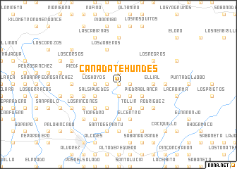
Cañada Te Hundes (El Seíbo, Dominican Republic)Cañada Te Hundes is a town in the El Seíbo region of Dominican Republic. An overview map of the region around Cañada Te Hundes is displayed below.
regional and 3d topo map of Cañada Te Hundes, Dominican Republic ::
Cañada Te Hundes airports ::
The nearest airport is LRM - La Romana Casa De Campo Intl, located 44.8 km south of Cañada Te Hundes.
Other airports nearby include PUJ - Punta Cana Intl (72.5 km south east), SDQ - Santo Domingo Las Americas Intl (86.0 km south west), STI - Santiago Cibao Intl (181.3 km west), POP - Puerto Plata Gregorio Luperon Intl (194.7 km north west), Nearby towns ::
Sabana de Arroyo Grande (0.0km north) //
Guayuyo (0.0km north) //
Coamo (1.8km east) //
Arroyo Grande (1.9km north) //
Potrero (1.8km west) //
Paso Dos Bocas (1.9km south) //
Las Cuchillas (2.6km south east) //
Los Hoyos (3.5km west) //
Arroyo Grande (3.5km west) //
Arroyo Mateo (4.1km south east) //
Tollín (4.1km south east) //
Cañada del Cacao Abajo (4.1km south east) //
Piedra Blanca (4.0km south east) //
Barrio Limoncillar (4.0km south east) //
Negro Viejo (4.1km south west) //
Arroyo Grande (4.1km south west) //
Salsipuedes (4.0km south west) //
Los Bejucos (4.0km south west) //
Limoncillar (5.1km south east) //
Cañada Prieta (5.1km south east) //
Dieguillo (5.1km south east) //
Capitán (5.1km south west) //
Cañada del Cacao Arriba (5.1km south west) //
El Lial (5.3km east) //
El Cabao (5.6km south) //
El Centro (5.8km south) //
Coamo Abajo (5.8km south) //
Piedra Blanca (5.6km west) //
La Mina (5.8km north) //
[all distances 'as the bird flies' and approximate] 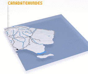 Places with similar names to Cañada Te Hundes, Dominican Republic :: Disclaimer :: Information on this page comes without warranty of any kind |
||
|
Where is Cañada Te Hundes? Elevation and coordinates ::
Latitude (lat): 18°51'0"N Longitude (lon): 68°59'0"W
Elevation (approx.): 197m (map arrows pan, magnifying glasses zoom) |
||
|
Visiting Cañada Te Hundes? Hotel/Accommodation ::
Book a hotel in Cañada Te Hundes Travel Guide ::
rental cars ::
car rental offers GPS waypoint ::
download a GPX waypoint (PoI) of Cañada Te Hundes for your GPS receiver
|
||