|
search place name
|
||
El Limpio (Santiago, Dominican Republic)El Limpio is a town in the Santiago region of Dominican Republic. An overview map of the region around El Limpio is displayed below.
regional and 3d topo map of El Limpio, Dominican Republic ::

El Limpio airports ::
The nearest airport is STI - Santiago Cibao Intl, located 31.2 km east of El Limpio.
Other airports nearby include POP - Puerto Plata Gregorio Luperon Intl (49.9 km north east), BRX - Barahona Maria Montez Intl (132.9 km south), CAP - Cap Haitien Intl (139.8 km west), SDQ - Santo Domingo Las Americas Intl (170.8 km south east), Nearby towns ::
Sierrecita (2.5km south east) //
Jaiquí Picado (3.7km north) //
Cuesta Abajo (4.0km south east) //
Albana (4.1km south west) //
Vidal Pichardo (5.1km south west) //
Eugenio Perdomo (5.1km south west) //
Potrero (5.1km north west) //
Guama (5.8km south) //
Marquen (5.8km south) //
Cuesta Arriba (7.0km east) //
Paralimón (7.6km south) //
Piedra Gorda (7.6km north) //
Loma Quemada (8.2km south east) //
Platanal (8.2km north east) //
Hatillo San Lorenzo (9.1km north east) //
Cañada del Caimito (10.2km south west) //
[all distances 'as the bird flies' and approximate] 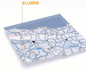 Places with similar names to El Limpio, Dominican Republic ::
Disclaimer :: Information on this page comes without warranty of any kind |
||
|
Where is El Limpio? Elevation and coordinates ::
Latitude (lat): 19°26'0"N Longitude (lon): 70°54'0"W
Elevation (approx.): 433m (map arrows pan, magnifying glasses zoom) |
||
|
Visiting El Limpio? Hotel/Accommodation ::
Book a hotel in El Limpio Travel Guide ::
rental cars ::
car rental offers GPS waypoint ::
download a GPX waypoint (PoI) of El Limpio for your GPS receiver
|
||