|
search place name
|
||
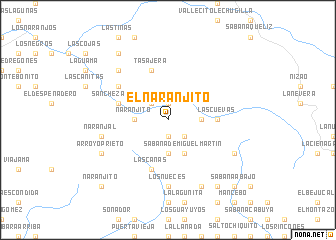
El Naranjito (Azua, Dominican Republic)El Naranjito is a town in the Azua region of Dominican Republic. An overview map of the region around El Naranjito is displayed below.
regional and 3d topo map of El Naranjito, Dominican Republic ::
El Naranjito airports ::
The nearest airport is BRX - Barahona Maria Montez Intl, located 62.9 km south west of El Naranjito.
Other airports nearby include STI - Santiago Cibao Intl (81.1 km north), SDQ - Santo Domingo Las Americas Intl (115.8 km east), POP - Puerto Plata Gregorio Luperon Intl (120.2 km north), PAP - Port-au-prince Toussaint Louverture Intl (164.9 km west), Nearby towns ::
La Finca (1.9km south) //
Palma Cana (1.9km north) //
Miguel Martí (2.6km south east) //
Cañada de Gabina (2.6km north west) //
La Piedra Colorada (3.5km east) //
Sabana de San Juan (3.7km south) //
Naranjito (3.5km west) //
Las Avispas (3.5km west) //
Sabana de Miguel Martín (4.1km south east) //
Las Cuevas (5.3km east) //
La Guama (5.6km west) //
Las Guamas (5.6km west) //
Sánchez Arriba (5.6km west) //
Tasajera (5.8km north) //
Las Canas (5.8km south) //
El Recado (6.4km north west) //
La Vereda Atravesada (7.4km south) //
El Paso de la Cruz (7.4km south) //
Los Nueces (7.4km south) //
Naranjal (7.3km west) //
Corcino (7.7km north west) //
La Fortuna (8.2km south east) //
Los Corralitos (7.9km south east) //
Arroyo Prieto (7.9km south west) //
Arroyo Hondo (9.1km south east) //
La Frontera (9.1km north west) //
Sabana Abajo (10.2km south east) //
Naranjito (10.2km south west) //
[all distances 'as the bird flies' and approximate] 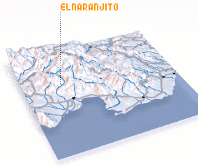 Places with similar names to El Naranjito, Dominican Republic ::
// El Naranjito (PA)
// El Naranjito (SV)
// El Naranjito (SV)
// El Naranjito (MX)
// El Naranjito (MX)
// El Naranjito (MX)
// El Naranjito (MX)
// El Naranjito (MX)
// El Naranjito (HN)
// El Naranjito (HN)
Disclaimer :: Information on this page comes without warranty of any kind |
||
|
Where is El Naranjito? Elevation and coordinates ::
Latitude (lat): 18°41'0"N Longitude (lon): 70°44'0"W
Elevation (approx.): 1409m (map arrows pan, magnifying glasses zoom) |
||
|
Visiting El Naranjito? Hotel/Accommodation ::
Book a hotel in El Naranjito Travel Guide ::
rental cars ::
car rental offers GPS waypoint ::
download a GPX waypoint (PoI) of El Naranjito for your GPS receiver
|
||