|
search place name
|
||
Grayumbo (Valverde, Dominican Republic)Grayumbo is a town in the Valverde region of Dominican Republic. An overview map of the region around Grayumbo is displayed below.
regional and 3d topo map of Grayumbo, Dominican Republic ::

Grayumbo airports ::
The nearest airport is POP - Puerto Plata Gregorio Luperon Intl, located 57.5 km east of Grayumbo.
Other airports nearby include STI - Santiago Cibao Intl (63.8 km south east), CAP - Cap Haitien Intl (113.0 km west), BRX - Barahona Maria Montez Intl (162.2 km south), PAP - Port-au-prince Toussaint Louverture Intl (176.4 km south west), Nearby towns ::
Pozo Prieto (1.7km west) //
La Caya (1.9km south) //
Palo Amarillo (1.7km east) //
Gurabo (4.1km north west) //
La Loma (4.0km north east) //
El Carril (4.0km south east) //
El Carril Arriba (4.0km south east) //
El Carril Abajo (5.1km south east) //
Arroyo de Agua (5.2km east) //
Los Toros (5.6km north) //
Las Carreras (5.6km south) //
Ranchete (5.6km east) //
Arroyo Caña (5.6km west) //
Jaibón (5.8km south) //
Gualete (5.8km north) //
Laguna de Solimán (6.6km north west) //
Palo de Leche (6.6km north west) //
Derramadero (7.2km west) //
Los Tres Pasos (7.2km east) //
Las Caobas (7.6km north east) //
Comedero (8.2km north east) //
Las Piraguas (7.9km north east) //
Laguna Salada (8.2km south east) //
Los Pinos (7.9km south east) //
Hatillo Palma (8.9km south west) //
Cañada Grande (8.9km north east) //
Guayacanes (9.1km south east) //
Cruce de Guayacanes (9.1km south east) //
Hatillo Palma Adentro (9.1km south west) //
[all distances 'as the bird flies' and approximate] 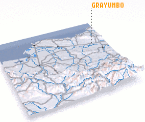 Places with similar names to Grayumbo, Dominican Republic ::
Disclaimer :: Information on this page comes without warranty of any kind |
||
|
Where is Grayumbo? Elevation and coordinates ::
Latitude (lat): 19°43'0"N Longitude (lon): 71°7'0"W
Elevation (approx.): 246m (map arrows pan, magnifying glasses zoom) |
||
|
Visiting Grayumbo? Hotel/Accommodation ::
Book a hotel in Grayumbo Travel Guide ::
rental cars ::
car rental offers GPS waypoint ::
download a GPX waypoint (PoI) of Grayumbo for your GPS receiver
|
||