|
search place name
|
||
La Ciénaga (La Vega, Dominican Republic)La Ciénaga is a town in the La Vega region of Dominican Republic. An overview map of the region around La Ciénaga is displayed below.
regional and 3d topo map of La Ciénaga, Dominican Republic ::

La Ciénaga airports ::
The nearest airport is STI - Santiago Cibao Intl, located 45.6 km north east of La Ciénaga.
Other airports nearby include POP - Puerto Plata Gregorio Luperon Intl (82.0 km north), BRX - Barahona Maria Montez Intl (94.6 km south), SDQ - Santo Domingo Las Americas Intl (143.1 km south east), CAP - Cap Haitien Intl (159.3 km north west), Nearby towns ::
El Paso de la Perra (1.8km east) //
Mata de Limón (3.5km east) //
El Higo (4.0km north east) //
Los Granizos (5.1km south west) //
El Tetero (5.6km east) //
Pajarito (5.6km east) //
Mata de Café (6.4km south east) //
Pino del Rayo (7.0km east) //
Manabao (7.0km east) //
La Angostura (7.2km east) //
El Alto (7.6km north east) //
Los Limones (7.6km north west) //
Los Montazos (9.1km north east) //
Arroyo Bonito (8.9km north east) //
[all distances 'as the bird flies' and approximate] 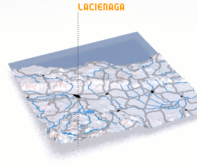 Places with similar names to La Ciénaga, Dominican Republic ::
Disclaimer :: Information on this page comes without warranty of any kind |
||
|
Where is La Ciénaga? Elevation and coordinates ::
Latitude (lat): 19°4'0"N Longitude (lon): 70°51'0"W
Elevation (approx.): 1063m (map arrows pan, magnifying glasses zoom) |
||
|
Visiting La Ciénaga? Hotel/Accommodation ::
Book a hotel in La Ciénaga Travel Guide ::
rental cars ::
car rental offers GPS waypoint ::
download a GPX waypoint (PoI) of La Ciénaga for your GPS receiver
|
||