|
search place name
|
||
La Gata (Peravia, Dominican Republic)La Gata is a town in the Peravia region of Dominican Republic. An overview map of the region around La Gata is displayed below.
regional and 3d topo map of La Gata, Dominican Republic ::

La Gata airports ::
The nearest airport is BRX - Barahona Maria Montez Intl, located 66.6 km south west of La Gata.
Other airports nearby include STI - Santiago Cibao Intl (92.9 km north), SDQ - Santo Domingo Las Americas Intl (97.7 km east), POP - Puerto Plata Gregorio Luperon Intl (131.9 km north), LRM - La Romana Casa De Campo Intl (177.0 km east), Nearby towns ::
La Demajagua (0.0km north) //
El Montazo (1.9km north) //
La Cruz (1.8km west) //
Los Palmaritos (1.8km west) //
La Cuchilla (1.9km south) //
Rancho de Francisco (1.9km south) //
La Mesa de Pino (2.6km south east) //
El Bejucal (3.7km north) //
Los Rincones (3.5km west) //
Los Corozos (3.5km west) //
Arroyo Colorado (3.7km south) //
Los Calabacitos (4.0km south east) //
El Pinar (4.0km south east) //
La Ciénaga (4.0km north west) //
Los Montes Quemados (4.0km north west) //
El Ojo de Agua (4.1km south east) //
El Perico (4.1km south east) //
Las Palmitas (4.0km south west) //
Las Piedras Malas (5.1km south east) //
Hanaclita (5.1km south east) //
Los Guanos (5.1km south west) //
Llano Monte (5.3km west) //
Rancho del Pino (5.3km west) //
Sabana Grande (5.3km east) //
Los Tramojos (5.6km west) //
El Memiso (5.8km south) //
El Coco (5.8km south) //
El Canal (5.6km east) //
Los Dos Ríos (5.6km east) //
[all distances 'as the bird flies' and approximate] 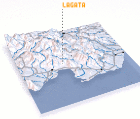 Places with similar names to La Gata, Dominican Republic ::
Disclaimer :: Information on this page comes without warranty of any kind |
||
|
Where is La Gata? Elevation and coordinates ::
Latitude (lat): 18°34'0"N Longitude (lon): 70°35'0"W
Elevation (approx.): 1016m (map arrows pan, magnifying glasses zoom) |
||
|
Visiting La Gata? Hotel/Accommodation ::
Book a hotel in La Gata Travel Guide ::
rental cars ::
car rental offers GPS waypoint ::
download a GPX waypoint (PoI) of La Gata for your GPS receiver
|
||