|
search place name
|
||
La Mesa de los Negros (Peravia, Dominican Republic)La Mesa de los Negros is a town in the Peravia region of Dominican Republic. An overview map of the region around La Mesa de los Negros is displayed below.
regional and 3d topo map of La Mesa de los Negros, Dominican Republic ::

La Mesa de los Negros airports ::
The nearest airport is BRX - Barahona Maria Montez Intl, located 64.3 km south west of La Mesa de los Negros.
Other airports nearby include STI - Santiago Cibao Intl (89.3 km north), SDQ - Santo Domingo Las Americas Intl (103.6 km east), POP - Puerto Plata Gregorio Luperon Intl (128.3 km north), PAP - Port-au-prince Toussaint Louverture Intl (175.1 km west), Nearby towns ::
Los Negros (0.0km north) //
Los Limones (1.8km west) //
Los Tramojos (1.9km south) //
Los Montes Quemados (2.6km south east) //
La Ciénaga (2.6km south east) //
Los Caimitos (2.6km north west) //
El Cercado (2.6km south west) //
Sabana Cabuya (2.6km south west) //
Llano Monte (3.7km south) //
Rancho del Pino (3.7km south) //
Mancebo (3.5km west) //
Los Naranjos (3.5km west) //
Los Rincones (4.1km south east) //
Los Corozos (4.1km south east) //
El Palmar (4.1km south west) //
Los Caimitos (4.1km south west) //
Los Amaceyitos (4.1km south west) //
Paso Hondo (4.1km south west) //
Sabana Abajo (4.0km north west) //
La Cruz (5.1km south east) //
Los Palmaritos (5.1km south east) //
Salto Chiquito (5.1km south west) //
El Limón (5.1km south west) //
Los Manaderos (5.3km west) //
El Bejucal (5.3km east) //
Pinalito (5.6km south) //
Las Palmitas (5.8km south) //
Arroyo Hondo (5.6km west) //
El Montazo (5.6km east) //
[all distances 'as the bird flies' and approximate] 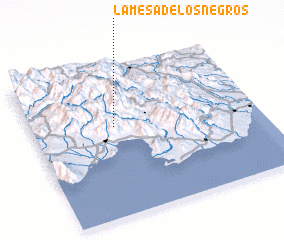 Places with similar names to La Mesa de los Negros, Dominican Republic :: Disclaimer :: Information on this page comes without warranty of any kind |
||
|
Where is La Mesa de los Negros? Elevation and coordinates ::
Latitude (lat): 18°36'0"N Longitude (lon): 70°38'0"W
Elevation (approx.): 1050m (map arrows pan, magnifying glasses zoom) |
||
|
Visiting La Mesa de los Negros? Hotel/Accommodation ::
Book a hotel in La Mesa de los Negros Travel Guide ::
rental cars ::
car rental offers GPS waypoint ::
download a GPX waypoint (PoI) of La Mesa de los Negros for your GPS receiver
|
||