|
search place name
|
||
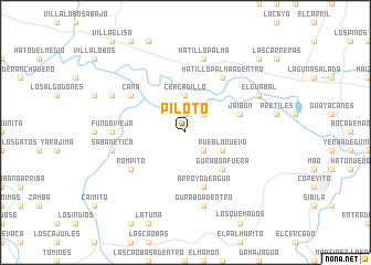
Piloto (Monte Cristi, Dominican Republic)Piloto is a town in the Monte Cristi region of Dominican Republic. An overview map of the region around Piloto is displayed below.
regional and 3d topo map of Piloto, Dominican Republic ::
Piloto airports ::
The nearest airport is STI - Santiago Cibao Intl, located 66.1 km east of Piloto.
Other airports nearby include POP - Puerto Plata Gregorio Luperon Intl (68.3 km east), CAP - Cap Haitien Intl (105.3 km west), BRX - Barahona Maria Montez Intl (149.5 km south), PAP - Port-au-prince Toussaint Louverture Intl (161.1 km south west), Nearby towns ::
Gurabo (1.9km north) //
Cartujo (2.5km north east) //
La Caída (2.5km south east) //
Cercadillo (3.7km north) //
Batey Portela (3.7km north) //
Pueblo Nuevo (4.0km south east) //
La Jagua (4.0km south east) //
Gurabo Afuera (5.1km south east) //
Jaibón (5.6km east) //
Arroyo de Agua (5.8km south) //
Cana (6.4km north west) //
Rompito (6.4km south west) //
Hatillo Palma Adentro (6.6km north east) //
Fundo Viejo (7.0km west) //
Cana Chapetón (7.0km west) //
Hatillo Palma (7.6km north) //
Sabanetica (7.2km west) //
Gurabo Adentro (7.6km south) //
Batey Cerro Gordo (7.9km north west) //
El Guabal (7.9km north east) //
Jaibón (10.2km north east) //
[all distances 'as the bird flies' and approximate]  Places with similar names to Piloto, Dominican Republic ::
Disclaimer :: Information on this page comes without warranty of any kind |
||
|
Where is Piloto? Elevation and coordinates ::
Latitude (lat): 19°36'0"N Longitude (lon): 71°12'0"W
Elevation (approx.): 60m (map arrows pan, magnifying glasses zoom) |
||
|
Visiting Piloto? Hotel/Accommodation ::
Book a hotel in Piloto Travel Guide ::
rental cars ::
car rental offers GPS waypoint ::
download a GPX waypoint (PoI) of Piloto for your GPS receiver
|
||