|
search place name
|
||
Piñita Arriba (Hato Mayor, Dominican Republic)Piñita Arriba is a town in the Hato Mayor region of Dominican Republic. An overview map of the region around Piñita Arriba is displayed below.
regional and 3d topo map of Piñita Arriba, Dominican Republic ::

Piñita Arriba airports ::
The nearest airport is SDQ - Santo Domingo Las Americas Intl, located 64.0 km south west of Piñita Arriba.
Other airports nearby include LRM - La Romana Casa De Campo Intl (65.6 km south east), PUJ - Punta Cana Intl (107.1 km east), STI - Santiago Cibao Intl (146.6 km north west), POP - Puerto Plata Gregorio Luperon Intl (162.4 km north west), Nearby towns ::
Juan Jiménez (1.9km south) //
Piñita Abajo (1.9km north) //
Colonia San Rafael (2.6km south west) //
Los Mampurrios (2.6km north west) //
Aserradero Barceló (2.6km south east) //
Carderón (4.1km south west) //
La Cumbre (4.0km south west) //
Los Guayos (4.0km north west) //
La Majagua (4.1km south east) //
El Perico (4.1km north east) //
Loma Larga (4.0km south east) //
Sabana de Barriolo (5.6km south) //
Palma Aletreada (5.3km east) //
El Toro (5.6km north) //
Filipinas (5.6km north) //
El Limpio (5.6km west) //
El Jobo (5.6km east) //
El Zumbador (5.8km north) //
Rancho Viejo (6.6km south west) //
Los Macos (6.4km south east) //
Bibiana (6.4km south east) //
Palmarito (6.6km south east) //
Piedra Redonda (6.6km north east) //
Buena Vista (7.4km south) //
Loma de Sombrero (7.3km west) //
Los Anegadizos (7.3km west) //
El Cabao (7.3km west) //
El Palmar (7.6km south) //
Los Callejones (7.6km north) //
[all distances 'as the bird flies' and approximate] 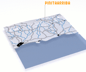 Places with similar names to Piñita Arriba, Dominican Republic ::
// Pin de Arriba (ES)
// Pandarāb (IR)
Disclaimer :: Information on this page comes without warranty of any kind |
||
|
Where is Piñita Arriba? Elevation and coordinates ::
Latitude (lat): 18°54'0"N Longitude (lon): 69°19'0"W
Elevation (approx.): 347m (map arrows pan, magnifying glasses zoom) |
||
|
Visiting Piñita Arriba? Hotel/Accommodation ::
Book a hotel in Piñita Arriba Travel Guide ::
rental cars ::
car rental offers GPS waypoint ::
download a GPX waypoint (PoI) of Piñita Arriba for your GPS receiver
|
||