|
search place name
|
||
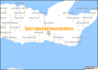
Santa Bárbara de Samaná (Samaná, Dominican Republic)Santa Bárbara de Samaná is a town in the Samaná region of Dominican Republic. An overview map of the region around Santa Bárbara de Samaná is displayed below.
regional and 3d topo map of Santa Bárbara de Samaná, Dominican Republic ::
Santa Bárbara de Samaná airports ::
The nearest airport is SDQ - Santo Domingo Las Americas Intl, located 94.7 km south west of Santa Bárbara de Samaná.
Other airports nearby include LRM - La Romana Casa De Campo Intl (94.9 km south east), PUJ - Punta Cana Intl (123.5 km south east), STI - Santiago Cibao Intl (137.0 km west), POP - Puerto Plata Gregorio Luperon Intl (144.6 km north west), Nearby towns ::
La Aguada (0.0km north) //
Acosta (0.0km north) //
La Palmilla (0.0km north) //
Río San Juan (1.9km north) //
María Luisa (1.8km west) //
La Verita (1.8km west) //
Monte Rojo (1.8km east) //
Anadel (1.9km south) //
Villa Clara (2.5km south east) //
La Bastilla (3.5km west) //
Romango (3.5km west) //
Noroeste (3.5km west) //
La Laguna (3.7km north) //
La Esperanza (4.1km north west) //
La Casualidad (4.1km north west) //
La Cruz (4.1km north west) //
Los Grini (4.0km south west) //
Los Gratinices (4.0km south east) //
Arroyo Grande (4.0km south east) //
Carenero (4.0km south east) //
Las Flechas (5.1km south east) //
Los Yagrumos (5.1km south east) //
Los Algarrobos (5.3km west) //
Callejón Javier (5.3km west) //
Honduras (5.6km west) //
Barrancolí (5.6km east) //
Doncel (5.6km west) //
La Majagua (6.6km north west) //
Los Cacaos (6.4km south east) //
[all distances 'as the bird flies' and approximate] 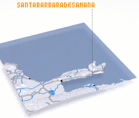 Places with similar names to Santa Bárbara de Samaná, Dominican Republic :: Disclaimer :: Information on this page comes without warranty of any kind |
||
|
Where is Santa Bárbara de Samaná? Elevation and coordinates ::
Latitude (lat): 19°13'0"N Longitude (lon): 69°19'0"W
Elevation (approx.): 151m (map arrows pan, magnifying glasses zoom) |
||
|
Visiting Santa Bárbara de Samaná? Hotel/Accommodation ::
Book a hotel in Santa Bárbara de Samaná Travel Guide ::
rental cars ::
car rental offers GPS waypoint ::
download a GPX waypoint (PoI) of Santa Bárbara de Samaná for your GPS receiver
|
||