|
search place name
|
||
Batengovo (Belarus)Batengovo is a town in Belarus. An overview map of the region around Batengovo is displayed below.
regional and 3d topo map of Batengovo, Belarus ::

Batengovo airports ::
The nearest airport is VTB - Vitebsk, located 67.6 km south of Batengovo.
Nearby towns ::
Tity (2.1km north east) //
Repishchi (3.9km north) //
Selezni (5.7km south) //
Andreyevo (4.9km north east) //
Turets (4.2km east) //
Lyakhovka (4.2km west) //
Dorokhi (7.4km north) //
Kayki (6.4km north east) //
Gati (6.0km north east) //
Maksimovka (7.7km south) //
Rudnya (5.4km north west) //
Mezha (6.8km south east) //
Lyalevshchina (5.6km south east) //
Remni (7.2km south west) //
Lugavskiya (8.5km north east) //
Chërnaya Bolotnitsa (8.5km north west) //
Bolotnitsa (8.5km north west) //
Belaya Bolotnitsa (8.5km north west) //
[all distances 'as the bird flies' and approximate] 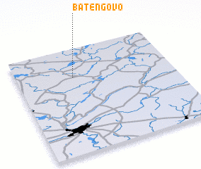 Places with similar names to Batengovo, Belarus ::
// Butenkov (RU)
// Batangafo (CF)
// Bodangafou (CF)
// Batnikovo (RU)
// Budnikovo (RU)
// Bet Neqofa (IL)
Disclaimer :: Information on this page comes without warranty of any kind |
||
|
Where is Batengovo? Elevation and coordinates ::
Latitude (lat): 55°44'0"N Longitude (lon): 30°22'0"E
Elevation (approx.): 161m (map arrows pan, magnifying glasses zoom) |
||
|
Visiting Batengovo? Hotel/Accommodation ::
Book a hotel in Batengovo Travel Guide ::
Buy a travel guide for Belarus rental cars ::
car rental offers GPS waypoint ::
download a GPX waypoint (PoI) of Batengovo for your GPS receiver
|
||