|
search place name
|
||
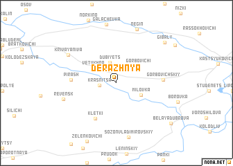
Derazhnya (Mahilyowskaya Voblastsʼ, Belarus)Derazhnya is a town in the Mahilyowskaya Voblastsʼ region of Belarus. An overview map of the region around Derazhnya is displayed below.
regional and 3d topo map of Derazhnya, Belarus ::
Derazhnya airports ::
The nearest airport is GME - Gomel, located 105.6 km south west of Derazhnya.
Other airports nearby include VTB - Vitebsk (225.9 km north west), Nearby towns ::
Krasnitsa (1.7km west) //
Dubiyets (3.3km north) //
Gorbovichi (3.4km north east) //
Vetukhna (3.3km north west) //
Milovka (3.1km south east) //
Kletki (6.1km south) //
Pirash (4.4km west) //
Gorbovichskiy (4.5km east) //
Sozon-Vladimirovskiy (8.8km south) //
Revensk (5.8km south west) //
Krivaya Niva (6.5km north west) //
Negin (8.8km north) //
Gibaly (8.0km north east) //
Belaya Dubrova (8.4km south east) //
[all distances 'as the bird flies' and approximate]  Places with similar names to Derazhnya, Belarus ::
// Derazhnya (UA)
// Dorozhnoye (UA)
// Druzhnoye (UA)
// Druzhnoye (UA)
// Druzhnoye (UA)
// Druzhnya (UA)
// Dorozhnaya (RU)
// Dorozhnoye (RU)
// Dorozhnoye (RU)
// Dorozhnoye (RU)
Disclaimer :: Information on this page comes without warranty of any kind |
||
|
Where is Derazhnya? Elevation and coordinates ::
Latitude (lat): 53°18'42"N Longitude (lon): 31°53'56"E
Elevation (approx.): 156m (map arrows pan, magnifying glasses zoom) |
||
|
Visiting Derazhnya? Hotel/Accommodation ::
Book a hotel in Derazhnya Travel Guide ::
Buy a travel guide for Belarus rental cars ::
car rental offers GPS waypoint ::
download a GPX waypoint (PoI) of Derazhnya for your GPS receiver
|
||