|
search place name
|
||
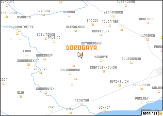
Dorogaya (Mahilyowskaya Voblastsʼ, Belarus)Dorogaya is a town in the Mahilyowskaya Voblastsʼ region of Belarus. An overview map of the region around Dorogaya is displayed below.
regional and 3d topo map of Dorogaya, Belarus ::
Dorogaya airports ::
The nearest airport is GME - Gomel, located 138.2 km south of Dorogaya.
Other airports nearby include VTB - Vitebsk (174.1 km north west), Nearby towns ::
Lushchevinka (2.1km south west) //
Gryunevskiy (2.9km north east) //
Bolvanovka (4.0km south west) //
Makovʼye (2.7km east) //
Novyy Kholoblin (4.9km south) //
Kostyushkovichi (4.3km south east) //
Pleshchina (6.3km north) //
Kholoblin (6.2km south) //
Komarovka (5.9km north east) //
Prusino (5.3km north west) //
Mostitskaya Sloboda (6.5km north west) //
Brodok (7.9km north) //
Gurko-Niva (5.1km west) //
Botvinovka (6.7km north west) //
Polonitsa (8.4km north east) //
Svadkevichi (8.2km south east) //
Komarovichi (9.4km south west) //
[all distances 'as the bird flies' and approximate]  Places with similar names to Dorogaya, Belarus ::
Disclaimer :: Information on this page comes without warranty of any kind |
||
|
Where is Dorogaya? Elevation and coordinates ::
Latitude (lat): 53°43'37"N Longitude (lon): 31°32'45"E
Elevation (approx.): 172m (map arrows pan, magnifying glasses zoom) |
||
|
Visiting Dorogaya? Hotel/Accommodation ::
Book a hotel in Dorogaya Travel Guide ::
Buy a travel guide for Belarus rental cars ::
car rental offers GPS waypoint ::
download a GPX waypoint (PoI) of Dorogaya for your GPS receiver
|
||