|
search place name
|
||
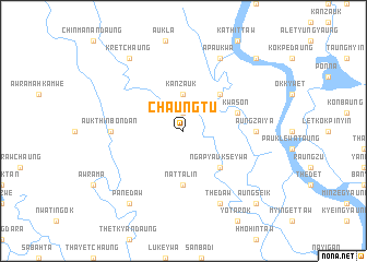
Chaungtu (Rakhine, Myanmar)Chaungtu is a town in the Rakhine region of Myanmar. An overview map of the region around Chaungtu is displayed below.
regional and 3d topo map of Chaungtu, Myanmar ::
Chaungtu airports ::
The nearest airport is AKY - Sittwe, located 57.5 km south of Chaungtu.
Other airports nearby include CXB - Cox's Bazar Coxs Bazar (133.0 km north west), KYP - Kyaukpyu (150.1 km south east), CGP - Chittagong Shah Amanat Intl (210.8 km north west), Nearby towns ::
Wadaung (1.9km north) //
Kanzauk (3.7km north) //
Myathle (5.1km south east) //
Ngapyaukseywa (5.1km south east) //
Auk Taungbyin (5.1km north east) //
Nattalin (5.6km south) //
Kwason (5.5km east) //
Aungzaiya (6.9km east) //
Auk Thinbondan (6.9km west) //
Thedaw (8.2km south east) //
Apaukwa (8.2km north east) //
Panedaw (9.1km south west) //
Kretchaung (9.1km north west) //
Aungseik (10.2km south east) //
Kaliāpara (10.2km north east) //
[all distances 'as the bird flies' and approximate]  Places with similar names to Chaungtu, Myanmar ::
// Shangtai (MM)
// Tiang Dua (MY)
// Chancuda (PT)
// Chiang Dao (TH)
// Chineket (RU)
// Chengti (BD)
// Chinácota (CO)
// Changoti (IN)
// Shencottah (IN)
// Shingāit (IN)
Disclaimer :: Information on this page comes without warranty of any kind |
||
|
Where is Chaungtu? Elevation and coordinates ::
Latitude (lat): 20°39'0"N Longitude (lon): 92°55'0"E
Elevation (approx.): 8m (map arrows pan, magnifying glasses zoom) |
||
|
Visiting Chaungtu? Hotel/Accommodation ::
Book a hotel in Chaungtu Travel Guide ::
Buy a travel guide for Myanmar rental cars ::
car rental offers GPS waypoint ::
download a GPX waypoint (PoI) of Chaungtu for your GPS receiver
|
||