|
search place name
|
||
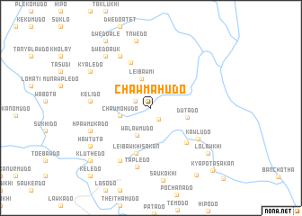
Chawmahudo (Kayin, Myanmar)Chawmahudo is a town in the Kayin region of Myanmar. An overview map of the region around Chawmahudo is displayed below.
regional and 3d topo map of Chawmahudo, Myanmar ::
Chawmahudo airports ::
The nearest airport is RGN - Yangon Intl, located 215.8 km south west of Chawmahudo.
Other airports nearby include MOG - Mong Hsat (303.6 km north east), Nearby towns ::
Shwe Kyahdo (1.7km south east) //
Pokyawdo (2.0km north west) //
Walawmudo (3.7km south west) //
Leibawmi (3.8km north) //
Chaumohudo (3.7km west) //
Dutado (4.4km east) //
Leibawkhi Sakan (5.9km south) //
Pawlawkhi (5.9km south east) //
Ploeywemudö (6.1km north west) //
Kawludo (6.8km south east) //
Dwedo (7.4km north west) //
Tapledo (7.5km south) //
Kelido (7.2km west) //
Poshwedo (7.5km south west) //
Hpawmukado (7.7km west) //
Dwedo Auk (8.4km north west) //
Tnwedo (8.5km north) //
Kyaledo (8.5km north west) //
Hawtuta (8.5km south west) //
Yaplodo (8.5km south west) //
Lolawkhi (8.8km south east) //
Kluthedo (9.7km south west) //
Pawkhi (9.7km south west) //
Bawtawdo (9.9km south east) //
Dwedo Ale (9.9km north west) //
Kyapota Sakan (10.6km south east) //
Keledo (11.0km south west) //
[all distances 'as the bird flies' and approximate]  Places with similar names to Chawmahudo, Myanmar ::
Disclaimer :: Information on this page comes without warranty of any kind |
||
|
Where is Chawmahudo? Elevation and coordinates ::
Latitude (lat): 18°31'32"N Longitude (lon): 97°16'3"E
Elevation (approx.): 542m (map arrows pan, magnifying glasses zoom) |
||
|
Visiting Chawmahudo? Hotel/Accommodation ::
Book a hotel in Chawmahudo Travel Guide ::
Buy a travel guide for Myanmar rental cars ::
car rental offers GPS waypoint ::
download a GPX waypoint (PoI) of Chawmahudo for your GPS receiver
|
||