|
search place name
|
||
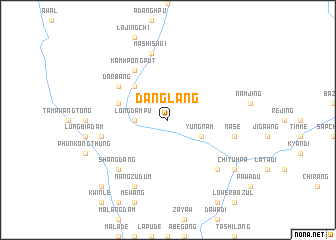
Danglang (Kachin State, Myanmar)Danglang is a town in the Kachin State region of Myanmar. An overview map of the region around Danglang is displayed below.
regional and 3d topo map of Danglang, Myanmar ::
Danglang airports ::
The nearest airport is PBU - Putao, located 104.6 km west of Danglang.
Other airports nearby include MYT - Myitkyina (242.1 km south west), Nearby towns ::
Zangilaw (3.3km west) //
Longdampu (3.3km west) //
Yungnam (3.8km south east) //
Wahkang (5.0km north west) //
Sungwang (5.3km west) //
Kamhpongput (6.5km north west) //
Darbang (6.2km north west) //
Mashishui (7.6km north) //
Tangthodam (6.8km west) //
Nasē (6.8km east) //
Shangdang (7.4km south west) //
Takwade (7.4km south east) //
Nangzudum (8.1km south west) //
Chituhpa (8.6km south east) //
Naludam (9.9km south west) //
[all distances 'as the bird flies' and approximate] 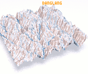 Places with similar names to Danglang, Myanmar ::
// Teng Leng (MM)
// Dengling (DE)
// Tengling (DE)
// Dong Luang (TH)
// Tanglongo (BF)
// Tankoulounga (BF)
// Dang-Lang (CF)
// Tangalanga (NG)
// Tong Long (LA)
// Tenggelanga (ID)
Disclaimer :: Information on this page comes without warranty of any kind |
||
|
Where is Danglang? Elevation and coordinates ::
Latitude (lat): 27°19'0"N Longitude (lon): 98°29'0"E
Elevation (approx.): 1572m (map arrows pan, magnifying glasses zoom) |
||
|
Visiting Danglang? Hotel/Accommodation ::
Book a hotel in Danglang Travel Guide ::
Buy a travel guide for Myanmar rental cars ::
car rental offers GPS waypoint ::
download a GPX waypoint (PoI) of Danglang for your GPS receiver
|
||