|
search place name
|
||
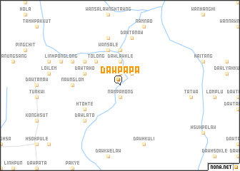
Dawpa-pa (Kayah, Myanmar)Dawpa-pa is a town in the Kayah region of Myanmar. An overview map of the region around Dawpa-pa is displayed below.
regional and 3d topo map of Dawpa-pa, Myanmar ::
Dawpa-pa airports ::
The nearest airport is HEH - Heho, located 114.3 km north west of Dawpa-pa.
Other airports nearby include MOG - Mong Hsat (214.2 km east), MDL - Mandalay Intl (248.9 km north west), Nearby towns ::
Dawta-ma (1.9km north) //
Dawwe-lè (1.9km north) //
Nam Pa-mong (1.9km south) //
Mè-hping (2.5km north east) //
Dawlaw-klè (3.7km north) //
To-long (5.1km north west) //
Wān Ngawn (5.6km north) //
Wān Sa-le (5.8km north) //
Dawhsaw-wè (5.5km west) //
Pa-no-daw (5.5km west) //
Dawta-hö (5.5km west) //
Mai Tung-hsong (6.4km north west) //
Htö-htè (6.4km south west) //
Nawng Lom (7.0km west) //
Dawlaw-hku (7.6km north) //
Dawta-naw (7.6km north) //
Wān Kang (7.6km north) //
Dawla-tö (7.6km south west) //
Wān Om-tüng (7.9km north west) //
[all distances 'as the bird flies' and approximate]  Places with similar names to Dawpa-pa, Myanmar ::
Disclaimer :: Information on this page comes without warranty of any kind |
||
|
Where is Dawpa-pa? Elevation and coordinates ::
Latitude (lat): 19°51'0"N Longitude (lon): 97°20'0"E
Elevation (approx.): 727m (map arrows pan, magnifying glasses zoom) |
||
|
Visiting Dawpa-pa? Hotel/Accommodation ::
Book a hotel in Dawpa-pa Travel Guide ::
Buy a travel guide for Myanmar rental cars ::
car rental offers GPS waypoint ::
download a GPX waypoint (PoI) of Dawpa-pa for your GPS receiver
|
||