|
search place name
|
||
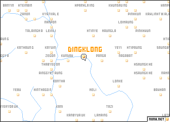
Dingklong (Shan, Myanmar)Dingklong is a town in the Shan region of Myanmar. An overview map of the region around Dingklong is displayed below.
regional and 3d topo map of Dingklong, Myanmar ::
Dingklong airports ::
The nearest airport is HEH - Heho, located 90.8 km north of Dingklong.
Other airports nearby include MDL - Mandalay Intl (209.1 km north), Nearby towns ::
Kundaw (3.5km west) //
Panga (3.5km east) //
Htinye (5.8km north) //
Zegon (7.0km west) //
Thabyegon (7.2km west) //
Meli (7.6km south) //
Kayu-in (7.2km west) //
Yeyi (7.2km east) //
Maungla (7.6km north east) //
Gwegon (7.6km south west) //
Kontha (7.6km south west) //
Ainggye Taung (7.9km south west) //
Kyauksit (8.9km north west) //
Leinli (8.9km north west) //
Lonke (8.9km south east) //
Ywagyi (10.2km south west) //
Nampon (10.2km north west) //
[all distances 'as the bird flies' and approximate] 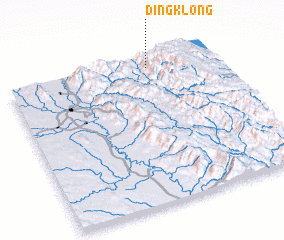 Places with similar names to Dingklong, Myanmar ::
// Tawngkalawng (IN)
// Dongkalang (ID)
// Tangkiling (ID)
// Tingkulang (ID)
// Tang Klang (VN)
// Dengklong (MM)
Disclaimer :: Information on this page comes without warranty of any kind |
||
|
Where is Dingklong? Elevation and coordinates ::
Latitude (lat): 19°56'0"N Longitude (lon): 96°41'0"E
Elevation (approx.): 452m (map arrows pan, magnifying glasses zoom) |
||
|
Visiting Dingklong? Hotel/Accommodation ::
Book a hotel in Dingklong Travel Guide ::
Buy a travel guide for Myanmar rental cars ::
car rental offers GPS waypoint ::
download a GPX waypoint (PoI) of Dingklong for your GPS receiver
|
||