|
search place name
|
||
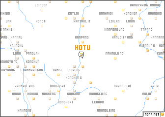
Ho-tu (Shan, Myanmar)Ho-tu is a town in the Shan region of Myanmar. An overview map of the region around Ho-tu is displayed below.
regional and 3d topo map of Ho-tu, Myanmar ::
Ho-tu airports ::
The nearest airport is HEH - Heho, located 122.3 km west of Ho-tu.
Other airports nearby include MOG - Mong Hsat (136.6 km east), KET - Kengtung (184.6 km east), THL - Tachilek Tachileik (207.1 km east), MDL - Mandalay Intl (232.7 km north west), Nearby towns ::
Nawngsawm (1.9km south) //
Mu-lu (1.9km south) //
Nawngmot (2.5km south west) //
Wān Pāng (3.7km north) //
Hku-weng (4.1km south west) //
Nawngpe (5.8km south) //
Kongkeng (5.8km south) //
Wān Mau (5.8km south) //
Namsi (6.4km south west) //
Loi-ai (6.9km east) //
Nawngleng (6.9km east) //
Wān Taklit (7.4km north) //
Wān Pong (7.6km south) //
Nawnghkan (7.6km south) //
Wān Ponglao (8.9km north east) //
Konghsai (9.1km south west) //
Loi-lam (10.1km north east) //
Tawngki (10.2km south west) //
[all distances 'as the bird flies' and approximate] 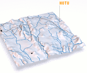 Places with similar names to Ho-tu, Myanmar ::
Disclaimer :: Information on this page comes without warranty of any kind |
||
|
Where is Ho-tu? Elevation and coordinates ::
Latitude (lat): 20°44'0"N Longitude (lon): 97°58'0"E
Elevation (approx.): 937m (map arrows pan, magnifying glasses zoom) |
||
|
Visiting Ho-tu? Hotel/Accommodation ::
Book a hotel in Ho-tu Travel Guide ::
Buy a travel guide for Myanmar rental cars ::
car rental offers GPS waypoint ::
download a GPX waypoint (PoI) of Ho-tu for your GPS receiver
|
||