|
search place name
|
||
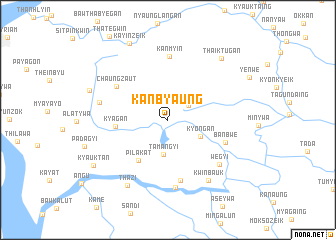
Kanbyaung (Yangon, Myanmar)Kanbyaung is a town in the Yangon region of Myanmar. An overview map of the region around Kanbyaung is displayed below.
regional and 3d topo map of Kanbyaung, Myanmar ::
Kanbyaung airports ::
The nearest airport is RGN - Yangon Intl, located 38.5 km north west of Kanbyaung.
Nearby towns ::
Pyinmagan (2.7km north east) //
Tamangyi (3.9km south) //
Kyongan (4.0km south east) //
Pilakat (5.5km south west) //
Kyagan (5.7km west) //
Chaungzaut (6.6km north west) //
Ywathit (6.8km south) //
Banbwe (6.7km east) //
Kanmyin (7.0km north) //
Uyin (7.5km south) //
Wegyi (7.4km south east) //
Yegyaw (7.5km west) //
Kwinbauk (8.1km south east) //
Thazi (8.5km south west) //
Thaiktugan (9.0km north east) //
Selongyi (9.0km west) //
Kayinzeik (9.5km north west) //
Kyauktan (9.5km south west) //
[all distances 'as the bird flies' and approximate] 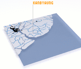 Places with similar names to Kanbyaung, Myanmar ::
// Qianbaying (CN)
// Qinbaoying (CN)
// Kanbya Anauk (MM)
// Kanbyaung (MM)
// Kanbyaung (MM)
// Kanbyu Anauk (MM)
Disclaimer :: Information on this page comes without warranty of any kind |
||
|
Where is Kanbyaung? Elevation and coordinates ::
Latitude (lat): 16°40'59"N Longitude (lon): 96°24'32"E
Elevation (approx.): 6m (map arrows pan, magnifying glasses zoom) |
||
|
Visiting Kanbyaung? Hotel/Accommodation ::
Book a hotel in Kanbyaung Travel Guide ::
Buy a travel guide for Myanmar rental cars ::
car rental offers GPS waypoint ::
download a GPX waypoint (PoI) of Kanbyaung for your GPS receiver
|
||