|
search place name
|
||
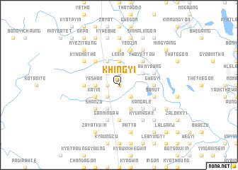
Khingyi (Myanmar)Khingyi is a town in Myanmar. An overview map of the region around Khingyi is displayed below.
regional and 3d topo map of Khingyi, Myanmar ::
Khingyi airports ::
The nearest airport is RGN - Yangon Intl, located 193.7 km south of Khingyi.
Nearby towns ::
Seikpugon (0.0km north) //
Payahnitsu Ale (1.8km west) //
Gonmin (1.9km north) //
Okpo (2.6km south west) //
Paukkon (2.6km south east) //
Thabyedan (2.6km north west) //
Yeshan (3.5km west) //
Leein (3.7km north) //
Payahnitsu Anauk (4.0km south west) //
Chinzu (4.0km south west) //
Kayin (4.0km south west) //
Nyaunglwin (4.1km south west) //
Nawkhin (4.1km south west) //
Domakhin (4.1km south east) //
Tingoktan (4.1km north west) //
Kyauktaing (4.1km north west) //
Kyeindawmyaung (4.0km north east) //
Shanzu (5.1km south west) //
Kogwa (5.1km north west) //
Myetnigwin (5.1km south east) //
Pandaw (5.1km south east) //
Kangale (5.1km south east) //
Thayettaw (5.1km north east) //
Gwegyi (5.3km east) //
Natyedwin (5.3km west) //
Kinwaing (5.6km south) //
Myozo Anauk (5.6km north) //
Samut (5.6km east) //
Ganmindaw (5.8km south) //
[all distances 'as the bird flies' and approximate]  Places with similar names to Khingyi, Myanmar ::
// Khingyi (MM)
Disclaimer :: Information on this page comes without warranty of any kind |
||
|
Where is Khingyi? Elevation and coordinates ::
Latitude (lat): 18°38'0"N Longitude (lon): 96°26'0"E
Elevation (approx.): 37m (map arrows pan, magnifying glasses zoom) |
||
|
Visiting Khingyi? Hotel/Accommodation ::
Book a hotel in Khingyi Travel Guide ::
Buy a travel guide for Myanmar rental cars ::
car rental offers GPS waypoint ::
download a GPX waypoint (PoI) of Khingyi for your GPS receiver
|
||