|
search place name
|
||
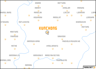
Kunchong (Shan, Myanmar)Kunchong is a town in the Shan region of Myanmar. An overview map of the region around Kunchong is displayed below.
regional and 3d topo map of Kunchong, Myanmar ::
Kunchong airports ::
The nearest airport is KET - Kengtung, located 132.3 km south east of Kunchong.
Other airports nearby include LSH - Lashio (155.7 km north west), MOG - Mong Hsat (208.9 km south), THL - Tachilek Tachileik (227.9 km south), Nearby towns ::
Sawksok (5.5km east) //
Ving Loi-nung (5.8km south) //
Mān Ngekhpak (6.3km south west) //
Hsuihsaw (6.5km north west) //
Panglat (6.5km north east) //
Namsawng (7.6km south east) //
Pānglak (8.2km north west) //
Ngekhte Tao (10.1km north west) //
Loi-lün (10.1km north east) //
[all distances 'as the bird flies' and approximate]  Places with similar names to Kunchong, Myanmar ::
// Khnushinak (AZ)
// Gonsiang (PH)
// Günching (DE)
// Kanching (MY)
// Konchinka (RU)
// Kenshunga (UG)
// Kan-ching (TW)
// Cunchang (CN)
// Cồn Chung (VN)
// Coun Chang (VN)
Disclaimer :: Information on this page comes without warranty of any kind |
||
|
Where is Kunchong? Elevation and coordinates ::
Latitude (lat): 22°24'0"N Longitude (lon): 99°8'0"E
Elevation (approx.): 1309m (map arrows pan, magnifying glasses zoom) |
||
|
Visiting Kunchong? Hotel/Accommodation ::
Book a hotel in Kunchong Travel Guide ::
Buy a travel guide for Myanmar rental cars ::
car rental offers GPS waypoint ::
download a GPX waypoint (PoI) of Kunchong for your GPS receiver
|
||