|
search place name
|
||
Kunhing (Shan, Myanmar)Kunhing is a town in the Shan region of Myanmar. An overview map of the region around Kunhing is displayed below.
regional and 3d topo map of Kunhing, Myanmar ::

Kunhing airports ::
The nearest airport is MOG - Mong Hsat, located 121.9 km south east of Kunhing.
Other airports nearby include KET - Kengtung (124.8 km east), THL - Tachilek Tachileik (180.5 km south east), HEH - Heho (181.3 km west), LSH - Lashio (198.6 km north), Nearby towns ::
Wān Kontawng (0.0km north) //
Wān Ho-kon (2.5km south west) //
Wān Ho-ke (3.5km west) //
Wān Hangkon (3.7km south) //
Nam-oi (3.9km north west) //
Wān Nawngmau (5.1km south west) //
Nammawn (5.6km north) //
Wān Panghai (5.6km south) //
Nā-tang (5.8km south) //
Wān Ho-hkö (6.9km west) //
Kon-aw (8.2km north west) //
Wān Lai-kam (8.9km north west) //
Hsai-hkao (10.1km north east) //
[all distances 'as the bird flies' and approximate] 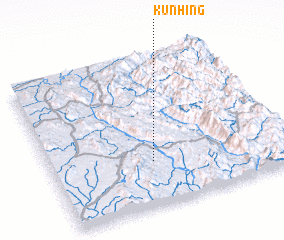 Places with similar names to Kunhing, Myanmar ::
// Kānī Hangah (IR)
// Kannaehang (KR)
// Canhungue (MZ)
// Cuanhanga (MZ)
// Cãnh An (2) (VN)
// Cồn Nhang (VN)
// Cồn Hương (VN)
// Kun Hang (VN)
// Quán Hàng (VN)
// Quan Hiến (2) (VN)
Disclaimer :: Information on this page comes without warranty of any kind |
||
|
Where is Kunhing? Elevation and coordinates ::
Latitude (lat): 21°18'0"N Longitude (lon): 98°26'0"E
Elevation (approx.): 489m (map arrows pan, magnifying glasses zoom) |
||
|
Visiting Kunhing? Hotel/Accommodation ::
Book a hotel in Kunhing Travel Guide ::
Buy a travel guide for Myanmar rental cars ::
car rental offers GPS waypoint ::
download a GPX waypoint (PoI) of Kunhing for your GPS receiver
|
||