|
search place name
|
||
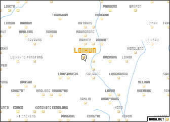
Loihun (Shan, Myanmar)Loihun is a town in the Shan region of Myanmar. An overview map of the region around Loihun is displayed below.
regional and 3d topo map of Loihun, Myanmar ::
Loihun airports ::
The nearest airport is HEH - Heho, located 97.4 km north west of Loihun.
Other airports nearby include MOG - Mong Hsat (168.2 km east), MDL - Mandalay Intl (225.8 km north west), KET - Kengtung (229.5 km north east), Nearby towns ::
Loihpwe (1.7km east) //
Nawngpyi (2.5km south east) //
Na-hkem (3.7km north) //
Sa-lawng (4.1km south east) //
Nahkemhkum (4.1km north east) //
Wānkot (5.1km north east) //
Loihsamhsip (5.1km south west) //
Makmong (5.2km east) //
Nawngpong (5.6km north) //
Wān Mong (6.4km south west) //
Namlin (6.4km south west) //
Pānglaw (6.4km south west) //
Nātawng (7.4km north) //
Nā-kun (7.6km north) //
Longmakpai (7.9km south east) //
Nawngpe (9.1km south east) //
Loisoi (9.1km south east) //
Namnoi (8.9km north west) //
Nawngywe (9.1km south west) //
Maklang (10.2km south east) //
Wān Māk (10.2km south west) //
Pāngtawng (10.2km south east) //
Pekheng (10.2km south west) //
[all distances 'as the bird flies' and approximate] 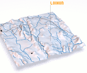 Places with similar names to Loihun, Myanmar ::
Disclaimer :: Information on this page comes without warranty of any kind |
||
|
Where is Loihun? Elevation and coordinates ::
Latitude (lat): 20°24'0"N Longitude (lon): 97°39'0"E
Elevation (approx.): 1020m (map arrows pan, magnifying glasses zoom) |
||
|
Visiting Loihun? Hotel/Accommodation ::
Book a hotel in Loihun Travel Guide ::
Buy a travel guide for Myanmar rental cars ::
car rental offers GPS waypoint ::
download a GPX waypoint (PoI) of Loihun for your GPS receiver
|
||