|
search place name
|
||
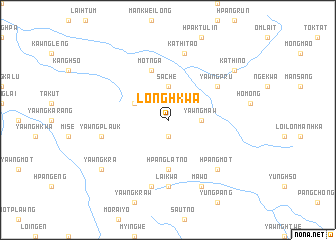
Longhkwa (Shan, Myanmar)Longhkwa is a town in the Shan region of Myanmar. An overview map of the region around Longhkwa is displayed below.
regional and 3d topo map of Longhkwa, Myanmar ::
Longhkwa airports ::
The nearest airport is LSH - Lashio, located 111.4 km west of Longhkwa.
Other airports nearby include KET - Kengtung (193.7 km south east), Nearby towns ::
Yawngluk (1.9km south) //
Yawngmaw (3.4km east) //
Sa-che (3.7km north) //
Mān Sun (3.9km north west) //
Hpanglat Nö (5.6km south) //
Motnga (5.8km north) //
Yawngp'ru (6.3km north east) //
Lai-kwa (7.4km south) //
Tai-sao (7.6km south) //
Yawngplauk (7.1km west) //
Kathi-tao (7.6km north) //
Hpangmot (7.6km south east) //
Maw O (8.2km south east) //
Yawngk'ra (8.8km south west) //
Kathi-no (8.8km north east) //
[all distances 'as the bird flies' and approximate] 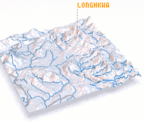 Places with similar names to Longhkwa, Myanmar ::
// Lonofoguwei (PG)
Disclaimer :: Information on this page comes without warranty of any kind |
||
|
Where is Longhkwa? Elevation and coordinates ::
Latitude (lat): 22°53'0"N Longitude (lon): 98°50'0"E
Elevation (approx.): 1253m (map arrows pan, magnifying glasses zoom) |
||
|
Visiting Longhkwa? Hotel/Accommodation ::
Book a hotel in Longhkwa Travel Guide ::
Buy a travel guide for Myanmar rental cars ::
car rental offers GPS waypoint ::
download a GPX waypoint (PoI) of Longhkwa for your GPS receiver
|
||