|
search place name
|
||
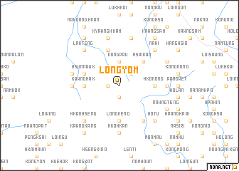
Löng-yom (Shan, Myanmar)Löng-yom is a town in the Shan region of Myanmar. An overview map of the region around Löng-yom is displayed below.
regional and 3d topo map of Löng-yom, Myanmar ::
Löng-yom airports ::
The nearest airport is LSH - Lashio, located 53.0 km north of Löng-yom.
Other airports nearby include MDL - Mandalay Intl (206.2 km south west), HEH - Heho (219.6 km south west), KET - Kengtung (232.9 km south east), MOG - Mong Hsat (267.4 km south east), Nearby towns ::
Kawngmu-leng (1.7km west) //
Kawng-mu-hsim (1.9km south) //
Mān Lang-ta (2.5km north east) //
Kōng-pau (3.7km north) //
Hsai-kau (5.0km north east) //
Kawng-hak (5.1km west) //
Mān Kiu (5.1km west) //
Longkeng (5.6km south) //
Hko-mong (5.1km east) //
Man Mak-hkaw (5.8km north) //
Hsun-mawk (5.5km west) //
Na-hsai (6.5km south east) //
Mōnghsong (6.8km west) //
Mān-kau-lōng (6.8km east) //
Man Nam-hu-hsim (6.8km east) //
Hko-hkan (7.4km south) //
Mān-kau-na-hpwi (7.1km west) //
Mān Mak-lang (7.1km west) //
Kyawng-hkam (7.6km north) //
Nā-mong (7.6km north) //
Hkamhseng (7.6km south west) //
Lak-teng (7.6km north west) //
Nā-nio (7.6km north west) //
Mān-kau-lōng (7.6km south east) //
Nā-nio (7.6km north east) //
Nā-wi (7.6km north east) //
Ho-tu (7.6km south east) //
Nawngteng (7.8km south east) //
Nam-hu-tai-hsan (7.8km north east) //
[all distances 'as the bird flies' and approximate]  Places with similar names to Löng-yom, Myanmar ::
// Long-yom (MM)
Disclaimer :: Information on this page comes without warranty of any kind |
||
|
Where is Löng-yom? Elevation and coordinates ::
Latitude (lat): 22°30'0"N Longitude (lon): 97°47'0"E
Elevation (approx.): 926m (map arrows pan, magnifying glasses zoom) |
||
|
Visiting Löng-yom? Hotel/Accommodation ::
Book a hotel in Löng-yom Travel Guide ::
Buy a travel guide for Myanmar rental cars ::
car rental offers GPS waypoint ::
download a GPX waypoint (PoI) of Löng-yom for your GPS receiver
|
||