|
search place name
|
||
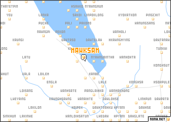
Mawksam (Shan, Myanmar)Mawksam is a town in the Shan region of Myanmar. An overview map of the region around Mawksam is displayed below.
regional and 3d topo map of Mawksam, Myanmar ::
Mawksam airports ::
The nearest airport is HEH - Heho, located 106.9 km north of Mawksam.
Other airports nearby include MDL - Mandalay Intl (237.5 km north west), Nearby towns ::
Kut Hpakkom (1.7km east) //
Dawhpu (1.7km east) //
Pangmai-nyè (1.7km west) //
Nawngleng (2.5km north east) //
Kwanglong (2.5km north west) //
Nyawngbintha (3.5km east) //
Hkawngmeng (3.7km south) //
Dawtè-law (4.1km north east) //
Kanbe (4.1km south east) //
Hpya-hte (5.1km north east) //
Lai-ya (5.1km north east) //
Dawhto-klo (5.1km south east) //
Dawta-so (5.1km north west) //
La-lè (6.6km south east) //
Pa-ko-mo (7.4km north) //
Longtawng (7.6km north) //
Panglai-hka (7.6km south) //
Pèkon (7.6km north west) //
Hkawng Mying (7.9km north east) //
Pa-li (8.2km north west) //
Dawma Kla (8.2km south east) //
Wān Hsa-tè (8.2km south west) //
Wān Ho-li (8.9km north east) //
Hsawlya-daw (9.1km south east) //
Engla (8.9km south west) //
Wān Makmōng (10.2km south east) //
Sa-aw-daw (10.2km south east) //
[all distances 'as the bird flies' and approximate]  Places with similar names to Mawksam, Myanmar ::
Disclaimer :: Information on this page comes without warranty of any kind |
||
|
Where is Mawksam? Elevation and coordinates ::
Latitude (lat): 19°49'0"N Longitude (lon): 97°4'0"E
Elevation (approx.): 886m (map arrows pan, magnifying glasses zoom) |
||
|
Visiting Mawksam? Hotel/Accommodation ::
Book a hotel in Mawksam Travel Guide ::
Buy a travel guide for Myanmar rental cars ::
car rental offers GPS waypoint ::
download a GPX waypoint (PoI) of Mawksam for your GPS receiver
|
||