|
search place name
|
||
Nā-hki-lek (Shan, Myanmar)Nā-hki-lek is a town in the Shan region of Myanmar. An overview map of the region around Nā-hki-lek is displayed below.
regional and 3d topo map of Nā-hki-lek, Myanmar ::

Nā-hki-lek airports ::
The nearest airport is MOG - Mong Hsat, located 92.3 km south east of Nā-hki-lek.
Other airports nearby include KET - Kengtung (124.3 km east), THL - Tachilek Tachileik (158.2 km east), HEH - Heho (179.2 km west), Nearby towns ::
Wān Tā-long (0.0km north) //
Tā-hsai (1.7km west) //
Wān Hwè-tanglai (2.5km south east) //
Pā-ke (2.5km north west) //
Wān Pangwo (3.7km south) //
Namhkam (3.7km north) //
Nawngwo (3.7km north) //
Konghka (5.6km north) //
Wān Hsi-paw (5.8km south) //
Wān Tongtau (5.8km south) //
Wān Hsophwe (6.9km east) //
Kēng Hkam (7.6km north) //
Wān Maksa-li (7.2km west) //
Wān Kyawng (7.6km north) //
Wān Nā-tawng (7.9km south west) //
Wān Namhsan (7.9km north west) //
[all distances 'as the bird flies' and approximate] 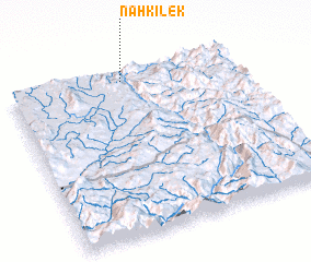 Places with similar names to Nā-hki-lek, Myanmar ::
// Ngahlauk (MM)
// Ngaleik (MM)
// Neuglück (DE)
// Neu Klockow (DE)
// Nikolaíika (GR)
// Naklik (PL)
// Nekielka (PL)
// Nikoliq (AL)
// Naklić (BA)
// Nikolić (BA)
Disclaimer :: Information on this page comes without warranty of any kind |
||
|
Where is Nā-hki-lek? Elevation and coordinates ::
Latitude (lat): 20°57'0"N Longitude (lon): 98°30'0"E
Elevation (approx.): 292m (map arrows pan, magnifying glasses zoom) |
||
|
Visiting Nā-hki-lek? Hotel/Accommodation ::
Book a hotel in Nā-hki-lek Travel Guide ::
Buy a travel guide for Myanmar rental cars ::
car rental offers GPS waypoint ::
download a GPX waypoint (PoI) of Nā-hki-lek for your GPS receiver
|
||