|
search place name
|
||
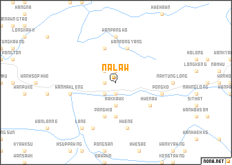
Nā-law (Shan, Myanmar)Nā-law is a town in the Shan region of Myanmar. An overview map of the region around Nā-law is displayed below.
regional and 3d topo map of Nā-law, Myanmar ::
Nā-law airports ::
The nearest airport is MOG - Mong Hsat, located 109.1 km east of Nā-law.
Other airports nearby include HEH - Heho (157.7 km west), THL - Tachilek Tachileik (178.6 km east), KET - Kengtung (182.2 km north east), Nearby towns ::
Hwè-hö (1.7km west) //
Wān Ho-hwè (1.9km north) //
Wān Maü (1.9km south) //
Wān Pāngping (2.5km north west) //
Konglom (2.5km south west) //
Makkawk (3.7km south) //
I-pāng (5.6km south) //
Wān Hwè-hkam (5.8km north) //
Pānghio (5.8km south) //
Wān Pong-yang (5.8km north) //
Hwè-naw (6.4km south east) //
Wān Pāngwo (7.4km north) //
Wān Kuntēng (7.2km west) //
Wān Makleng (7.2km west) //
Pongkö (7.2km east) //
Hwè-nè (7.6km south) //
Kongtüng (8.2km south west) //
La-ne (9.1km south west) //
[all distances 'as the bird flies' and approximate] 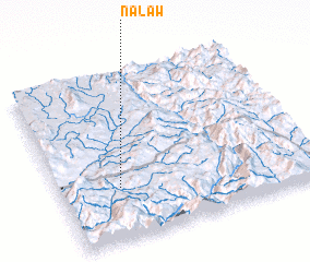 Places with similar names to Nā-law, Myanmar ::
Disclaimer :: Information on this page comes without warranty of any kind |
||
|
Where is Nā-law? Elevation and coordinates ::
Latitude (lat): 20°19'0"N Longitude (lon): 98°14'0"E
Elevation (approx.): 690m (map arrows pan, magnifying glasses zoom) |
||
|
Visiting Nā-law? Hotel/Accommodation ::
Book a hotel in Nā-law Travel Guide ::
Buy a travel guide for Myanmar rental cars ::
car rental offers GPS waypoint ::
download a GPX waypoint (PoI) of Nā-law for your GPS receiver
|
||