|
search place name
|
||
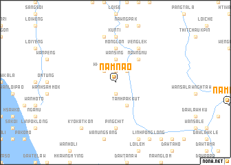
Namnao (Kayah, Myanmar)Namnao is a town in the Kayah region of Myanmar. An overview map of the region around Namnao is displayed below.
regional and 3d topo map of Namnao, Myanmar ::
Namnao airports ::
The nearest airport is HEH - Heho, located 96.3 km north west of Namnao.
Other airports nearby include MDL - Mandalay Intl (230.4 km north west), Nearby towns ::
Sang Hkam (1.9km north) //
Ho-la (1.9km south) //
Pang Lao (1.9km south) //
U-ri-daw (2.5km north east) //
Hkok-lao (2.5km north west) //
Wan Sing (3.7km north) //
Tamhpak-kut (4.1km south east) //
Nawngmu (5.1km north east) //
Monglon (5.6km north) //
Nawngpa-yin (5.6km north) //
Veng-lek (6.6km north east) //
Kunti (7.4km north) //
Ping Chit (7.4km south) //
Ho-hkai (7.6km north) //
Kyo-kat-kon (9.1km south west) //
[all distances 'as the bird flies' and approximate] 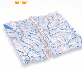 Places with similar names to Namnao, Myanmar ::
Disclaimer :: Information on this page comes without warranty of any kind |
||
|
Where is Namnao? Elevation and coordinates ::
Latitude (lat): 19°58'0"N Longitude (lon): 97°12'0"E
Elevation (approx.): 816m (map arrows pan, magnifying glasses zoom) |
||
|
Visiting Namnao? Hotel/Accommodation ::
Book a hotel in Namnao Travel Guide ::
Buy a travel guide for Myanmar rental cars ::
car rental offers GPS waypoint ::
download a GPX waypoint (PoI) of Namnao for your GPS receiver
|
||