|
search place name
|
||
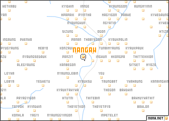
Nangaw (Shan, Myanmar)Nangaw is a town in the Shan region of Myanmar. An overview map of the region around Nangaw is displayed below.
regional and 3d topo map of Nangaw, Myanmar ::
Nangaw airports ::
The nearest airport is HEH - Heho, located 31.9 km south of Nangaw.
Other airports nearby include MDL - Mandalay Intl (105.4 km north west), LSH - Lashio (243.6 km north east), Nearby towns ::
Lebyin (1.7km east) //
Teinggon (2.5km north west) //
Tadagyi (2.5km north east) //
Panzit (3.5km west) //
Ingwun (3.5km east) //
Panseingbin (3.9km north west) //
Konzaung (3.9km north west) //
Panan (4.1km north west) //
Kanbegon (3.9km south west) //
Thabyegon (4.1km north east) //
On-et (5.1km north west) //
Nyaunglebin (5.1km south west) //
Pong-in (5.1km north east) //
Singat (5.1km north east) //
Ye-u (5.1km south east) //
Myekya (5.2km east) //
Kolon (5.6km south) //
Kyauksu (5.6km south) //
Talaing (5.5km east) //
Tunbimyaung (5.5km east) //
Chaunggya (5.8km south) //
Nyaunggauk (5.8km north) //
Pinnegon (5.8km north) //
Sizung (6.5km north west) //
Kunda (6.4km north east) //
Mai-in (6.5km north east) //
Ogon (6.5km north east) //
Nyaungbinwein (7.4km north) //
Hkongpa (6.9km east) //
[all distances 'as the bird flies' and approximate]  Places with similar names to Nangaw, Myanmar ::
Disclaimer :: Information on this page comes without warranty of any kind |
||
|
Where is Nangaw? Elevation and coordinates ::
Latitude (lat): 21°1'0"N Longitude (lon): 96°41'0"E
Elevation (approx.): 1132m (map arrows pan, magnifying glasses zoom) |
||
|
Visiting Nangaw? Hotel/Accommodation ::
Book a hotel in Nangaw Travel Guide ::
Buy a travel guide for Myanmar rental cars ::
car rental offers GPS waypoint ::
download a GPX waypoint (PoI) of Nangaw for your GPS receiver
|
||