|
search place name
|
||
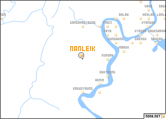
Nanleik (Sagaing, Myanmar)Nanleik is a town in the Sagaing region of Myanmar. An overview map of the region around Nanleik is displayed below.
regional and 3d topo map of Nanleik, Myanmar ::
Nanleik airports ::
The nearest airport is IMF - Imphal, located 98.7 km north west of Nanleik.
Other airports nearby include AJL - Aizwal Aizawl (182.1 km west), IXS - Silchar (182.9 km north west), Nearby towns ::
Kundaw (5.1km east) //
Metset (5.1km east) //
Maukpalin (6.3km south east) //
Auktaung (6.3km south east) //
Henin (6.5km south east) //
Taungzwe (6.5km south east) //
Gandamagyaung (7.4km north) //
Kadugyaung (7.4km south) //
Nga-ywa (7.5km north east) //
Kaya (7.5km north east) //
Ohnebok (7.7km north east) //
Kundaung (7.7km north east) //
Sittaw (8.1km north east) //
Sittaung (8.1km north east) //
Taunggon (8.1km south east) //
Thazi (9.0km north east) //
Mogaung (8.8km north east) //
Ngapyawdaw (10.0km north east) //
[all distances 'as the bird flies' and approximate] 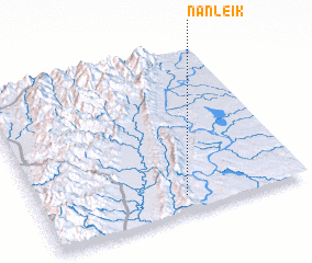 Places with similar names to Nanleik, Myanmar ::
// Nanlégué (BF)
// Nonoalco (MX)
// Ninalaque (PE)
// Nanelago (MZ)
// Nanlaca (MZ)
// Nan-liao-k'ou (TW)
// Gninaoloké (CI)
Disclaimer :: Information on this page comes without warranty of any kind |
||
|
Where is Nanleik? Elevation and coordinates ::
Latitude (lat): 24°6'0"N Longitude (lon): 94°33'0"E
Elevation (approx.): 153m (map arrows pan, magnifying glasses zoom) |
||
|
Visiting Nanleik? Hotel/Accommodation ::
Book a hotel in Nanleik Travel Guide ::
Buy a travel guide for Myanmar rental cars ::
car rental offers GPS waypoint ::
download a GPX waypoint (PoI) of Nanleik for your GPS receiver
|
||