|
search place name
|
||
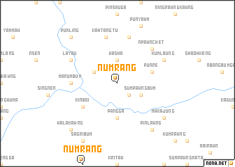
Numrang (Kachin State, Myanmar)Numrang is a town in the Kachin State region of Myanmar. An overview map of the region around Numrang is displayed below.
regional and 3d topo map of Numrang, Myanmar ::
Numrang airports ::
The nearest airport is MYT - Myitkyina, located 99.3 km south west of Numrang.
Other airports nearby include PBU - Putao (132.4 km north), Nearby towns ::
Hkachang (2.5km south east) //
Washa (3.7km north) //
Sumpawngbum (3.8km south east) //
Masizau (3.8km north west) //
Pang Ga (5.6km south) //
Punre (5.3km east) //
Kinboi (6.2km south west) //
Marumbum (6.7km west) //
Kahtangtu (7.6km north) //
Ngumla (7.6km north) //
Npawnchet (7.5km north east) //
Lāyau (7.6km north west) //
Kumlaung (7.6km north east) //
Pinlawng (8.9km south east) //
Makajung (8.7km south east) //
Walakawng (10.0km south west) //
Pumling (10.0km north west) //
[all distances 'as the bird flies' and approximate] 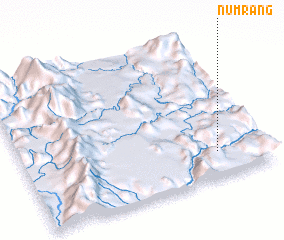 Places with similar names to Numrang, Myanmar ::
// Numbrawng (MM)
// Numrang (MM)
// Numrawng (MM)
// Nammering (DE)
// Nemering (DE)
// Niméringa (TD)
// Nemoringo (CD)
// Numbiaranga (EC)
// Namuiranga (MZ)
// Numaronaga (PG)
Disclaimer :: Information on this page comes without warranty of any kind |
||
|
Where is Numrang? Elevation and coordinates ::
Latitude (lat): 26°11'0"N Longitude (lon): 97°48'0"E
Elevation (approx.): 541m (map arrows pan, magnifying glasses zoom) |
||
|
Visiting Numrang? Hotel/Accommodation ::
Book a hotel in Numrang Travel Guide ::
Buy a travel guide for Myanmar rental cars ::
car rental offers GPS waypoint ::
download a GPX waypoint (PoI) of Numrang for your GPS receiver
|
||