|
search place name
|
||
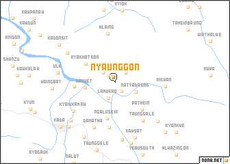
Nyaunggon (Mon State, Myanmar)Nyaunggon is a town in the Mon State region of Myanmar. An overview map of the region around Nyaunggon is displayed below.
regional and 3d topo map of Nyaunggon, Myanmar ::
Nyaunggon airports ::
The nearest airport is RGN - Yangon Intl, located 203.2 km west of Nyaunggon.
Other airports nearby include LPT - Lampang (276.0 km north east), Nearby towns ::
Kyaikhtaw (1.5km north west) //
Wabyangon (1.8km south east) //
Migathit (2.2km north east) //
Wabyangon (2.4km north west) //
Lamukho (2.8km south) //
Natyadaung (3.7km south east) //
Kawwet (4.8km west) //
Kyakhatkon (5.5km north west) //
Ngaluseik (6.1km south) //
Pathein (6.2km south east) //
Ngabyema (6.4km west) //
Pawlawgon (7.4km south) //
Taunggale (7.6km south east) //
Hlaing (8.0km north) //
Damatha (8.1km south west) //
Mikwan (7.9km east) //
Kyaikkamaw (8.0km south west) //
Shwewagyaung (8.8km north west) //
Ngahpechaung (9.3km south east) //
Thayetkon (9.4km south west) //
Kya-in (10.3km south west) //
Kada (11.2km south west) //
Tada-u (11.3km south east) //
[all distances 'as the bird flies' and approximate] 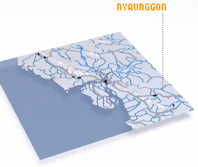 Places with similar names to Nyaunggon, Myanmar ::
Disclaimer :: Information on this page comes without warranty of any kind |
||
|
Where is Nyaunggon? Elevation and coordinates ::
Latitude (lat): 16°17'24"N Longitude (lon): 97°55'35"E
Elevation (approx.): 7m (map arrows pan, magnifying glasses zoom) |
||
|
Visiting Nyaunggon? Hotel/Accommodation ::
Book a hotel in Nyaunggon Travel Guide ::
Buy a travel guide for Myanmar rental cars ::
car rental offers GPS waypoint ::
download a GPX waypoint (PoI) of Nyaunggon for your GPS receiver
|
||