|
search place name
|
||
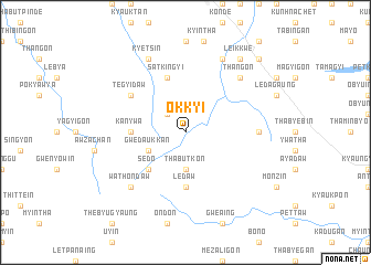
Okkyi (Mandalay, Myanmar)Okkyi is a town in the Mandalay region of Myanmar. An overview map of the region around Okkyi is displayed below.
regional and 3d topo map of Okkyi, Myanmar ::
Okkyi airports ::
The nearest airport is MDL - Mandalay Intl, located 88.9 km north east of Okkyi.
Other airports nearby include HEH - Heho (123.0 km east), Nearby towns ::
Okgale (2.5km north west) //
Thabutkon (3.7km south) //
Gwedaukkan (3.9km south west) //
Sedo (5.1km south west) //
Kanywa (5.2km west) //
Ledaw (5.6km south) //
Satkingyi (5.8km north) //
Pyundaw (5.8km north) //
Tegyidaw (6.4km north west) //
Pyaukseikkon (6.9km east) //
Thangon (7.6km north east) //
Wathondaw (7.6km south west) //
Kyetsin (8.2km north west) //
Ason (8.2km north west) //
Yonbinzauk (8.2km north east) //
Kyaukpu (9.0km north east) //
Leikkwe (9.0km north east) //
Sedaw (10.1km north east) //
[all distances 'as the bird flies' and approximate] 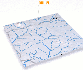 Places with similar names to Okkyi, Myanmar ::
Disclaimer :: Information on this page comes without warranty of any kind |
||
|
Where is Okkyi? Elevation and coordinates ::
Latitude (lat): 20°58'0"N Longitude (lon): 95°38'0"E
Elevation (approx.): 330m (map arrows pan, magnifying glasses zoom) |
||
|
Visiting Okkyi? Hotel/Accommodation ::
Book a hotel in Okkyi Travel Guide ::
Buy a travel guide for Myanmar rental cars ::
car rental offers GPS waypoint ::
download a GPX waypoint (PoI) of Okkyi for your GPS receiver
|
||