|
search place name
|
||
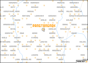
Pangtangnok (Shan, Myanmar)Pangtangnok is a town in the Shan region of Myanmar. An overview map of the region around Pangtangnok is displayed below.
regional and 3d topo map of Pangtangnok, Myanmar ::
Pangtangnok airports ::
The nearest airport is HEH - Heho, located 79.4 km south west of Pangtangnok.
Other airports nearby include MDL - Mandalay Intl (168.9 km north west), MOG - Mong Hsat (196.6 km east), LSH - Lashio (211.8 km north), Nearby towns ::
Hpa-hsö (1.9km north) //
Konglum (3.5km east) //
Hpā-loi (3.7km north) //
Ho-pāng (3.9km south east) //
Tan-e (3.9km north east) //
Kawng Hka (4.1km south west) //
Nā-hpai (4.1km north east) //
Ho Nam (3.9km south west) //
Nā-sam (5.1km south east) //
Kawkke (5.1km north east) //
Kyi-pong (5.1km south west) //
Long-yok (5.6km south) //
Wengkoi (5.5km east) //
Konghsa (5.8km south) //
Kio-ning (5.8km south) //
Naw Pan Ping (5.8km south) //
Loi Pek Man (5.8km north) //
Hsi Nin (5.5km west) //
Pang Nim (5.5km west) //
Kong Hsot (5.5km west) //
Konghsai (6.5km north east) //
Kong Hsong (6.4km south west) //
Hannam (6.4km north east) //
Ka-hpi (7.4km south) //
Wān Hwè-möng (7.6km south) //
Loi-tap (7.6km south) //
Wān Loi-sawn (7.6km south) //
Hwè Ha (7.6km south) //
Nā-chi Wam Tau (7.2km west) //
[all distances 'as the bird flies' and approximate]  Places with similar names to Pangtangnok, Myanmar :: Disclaimer :: Information on this page comes without warranty of any kind |
||
|
Where is Pangtangnok? Elevation and coordinates ::
Latitude (lat): 21°5'0"N Longitude (lon): 97°28'0"E
Elevation (approx.): 1589m (map arrows pan, magnifying glasses zoom) |
||
|
Visiting Pangtangnok? Hotel/Accommodation ::
Book a hotel in Pangtangnok Travel Guide ::
Buy a travel guide for Myanmar rental cars ::
car rental offers GPS waypoint ::
download a GPX waypoint (PoI) of Pangtangnok for your GPS receiver
|
||