|
search place name
|
||
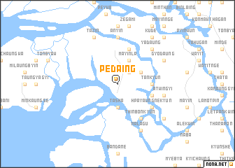
Pedaing (Myanmar)Pedaing is a town in Myanmar. An overview map of the region around Pedaing is displayed below.
regional and 3d topo map of Pedaing, Myanmar ::
Pedaing airports ::
The nearest airport is MGZ - Myeik, located 25.1 km north west of Pedaing.
Other airports nearby include HHQ - Prachuap Khiri Khan Hua Hin (141.5 km east), BKK - Bangkok Intl (276.6 km north east), Nearby towns ::
Mayinla (2.6km north east) //
Tasha (3.7km south) //
Pabwi (4.1km north east) //
Mayinla (4.1km north east) //
Mathe (4.1km north east) //
Tankyun (5.4km east) //
Sihposhwe (5.7km east) //
Payatwet (5.8km north) //
Hpayaungnekyun (6.6km south east) //
Thinbonkyun (6.6km south east) //
Anyin (7.4km north) //
Atwingyi (7.5km east) //
Yadaung (7.8km north east) //
Malagu (8.3km south east) //
Gyodaung (8.1km north east) //
Tazin (8.3km north west) //
Mayanbin (9.1km south east) //
Kude (9.2km north east) //
Mingok (10.4km north east) //
[all distances 'as the bird flies' and approximate]  Places with similar names to Pedaing, Myanmar ::
Disclaimer :: Information on this page comes without warranty of any kind |
||
|
Where is Pedaing? Elevation and coordinates ::
Latitude (lat): 12°14'0"N Longitude (lon): 98°43'0"E
Elevation (approx.): 17m (map arrows pan, magnifying glasses zoom) |
||
|
Visiting Pedaing? Hotel/Accommodation ::
Book a hotel in Pedaing Travel Guide ::
Buy a travel guide for Myanmar rental cars ::
car rental offers GPS waypoint ::
download a GPX waypoint (PoI) of Pedaing for your GPS receiver
|
||