|
search place name
|
||
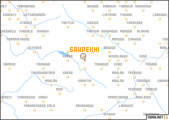
Sawpekhi (Myanmar)Sawpekhi is a town in Myanmar. An overview map of the region around Sawpekhi is displayed below.
regional and 3d topo map of Sawpekhi, Myanmar ::
Sawpekhi airports ::
The nearest airport is RGN - Yangon Intl, located 183.6 km south west of Sawpekhi.
Nearby towns ::
Mosawko (0.0km north) //
Khedo Atet (1.9km south) //
Wamilu (2.6km north east) //
Khedo (3.5km west) //
Tauwedo (4.0km south east) //
Patkawki (4.0km north west) //
Khedo (5.1km south west) //
Bawseko (5.3km east) //
Kamuthi (5.6km south) //
Thetkhi (5.8km north) //
Dedaukhi (5.8km south) //
Bawudo (5.6km east) //
Simudo (6.6km north east) //
Payukhi (6.6km north east) //
Hikholawdo (7.0km east) //
Kebo (7.3km east) //
Kosido (7.6km north) //
Semuhedo (7.7km north east) //
Mawlaw (8.0km south east) //
Pomudo (8.0km north east) //
Thetchi (8.2km north west) //
Muki (9.1km south west) //
Mawlaw (9.0km south east) //
Mawlaw (9.0km south west) //
[all distances 'as the bird flies' and approximate] 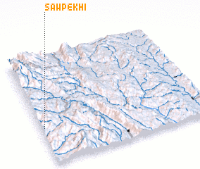
Disclaimer :: Information on this page comes without warranty of any kind |
||
|
Where is Sawpekhi? Elevation and coordinates ::
Latitude (lat): 18°20'0"N Longitude (lon): 97°1'0"E
Elevation (approx.): 897m (map arrows pan, magnifying glasses zoom) |
||
|
Visiting Sawpekhi? Hotel/Accommodation ::
Book a hotel in Sawpekhi Travel Guide ::
Buy a travel guide for Myanmar rental cars ::
car rental offers GPS waypoint ::
download a GPX waypoint (PoI) of Sawpekhi for your GPS receiver
|
||