|
search place name
|
||
Sihaung Ashe (Sagaing, Myanmar)Sihaung Ashe is a town in the Sagaing region of Myanmar. An overview map of the region around Sihaung Ashe is displayed below.
regional and 3d topo map of Sihaung Ashe, Myanmar ::

Sihaung Ashe airports ::
The nearest airport is AJL - Aizwal Aizawl, located 164.4 km north west of Sihaung Ashe.
Other airports nearby include IMF - Imphal (212.4 km north), MDL - Mandalay Intl (233.0 km south east), Nearby towns ::
Sihaung Myauk (2.5km north west) //
Tintha (3.7km south) //
Sihaung Taung (3.4km west) //
Kondo (4.1km north west) //
Kyawywa (3.9km south west) //
Nat-in (3.9km north east) //
Nwa (3.9km south east) //
Bogon (6.5km north west) //
Shābo (6.5km south west) //
Kokko (6.5km south east) //
[all distances 'as the bird flies' and approximate] 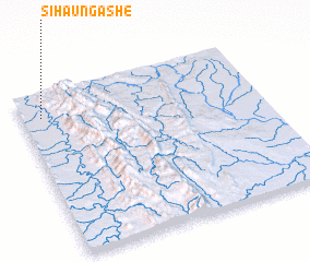 Places with similar names to Sihaung Ashe, Myanmar ::
// Zhanakush (KZ)
// Zhanakush (KZ)
// Zhanakush (KZ)
// Zhanakush (KZ)
// Zhanakush (KZ)
// Zhongsha (CN)
// Zhangsi'ao (CN)
// Zhengshi'ao (CN)
// Zhangshu'ao (CN)
// Zhengshi (CN)
Disclaimer :: Information on this page comes without warranty of any kind |
||
|
Where is Sihaung Ashe? Elevation and coordinates ::
Latitude (lat): 22°51'0"N Longitude (lon): 94°5'0"E
Elevation (approx.): 138m (map arrows pan, magnifying glasses zoom) |
||
|
Visiting Sihaung Ashe? Hotel/Accommodation ::
Book a hotel in Sihaung Ashe Travel Guide ::
Buy a travel guide for Myanmar rental cars ::
car rental offers GPS waypoint ::
download a GPX waypoint (PoI) of Sihaung Ashe for your GPS receiver
|
||