|
search place name
|
||
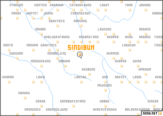
Sindibum (Kachin State, Myanmar)Sindibum is a town in the Kachin State region of Myanmar. An overview map of the region around Sindibum is displayed below.
regional and 3d topo map of Sindibum, Myanmar ::
Sindibum airports ::
The nearest airport is LSH - Lashio, located 121.6 km south of Sindibum.
Other airports nearby include MYT - Myitkyina (153.3 km north), Nearby towns ::
Ndung-gahtawng (2.5km north west) //
Wajau (3.7km north) //
Mādangyang (4.1km north east) //
Hkubung (4.1km south east) //
Mān Lung (4.1km north west) //
Nbawpa (3.9km south west) //
Pita (5.0km north east) //
Nambai Lung (5.1km west) //
Lahtaw (5.6km south) //
Mān Loi (5.4km west) //
Hkalu-gahtawng (6.3km north west) //
Hkannoi (6.8km east) //
Mān Kang (7.4km north) //
Gahkyeng (7.0km west) //
Lau Kung (7.5km north east) //
Uma (7.5km south east) //
Hkapra (7.7km north east) //
Wā-sha (8.8km north east) //
Majigung (9.0km south east) //
Gahkyeng (9.0km north west) //
[all distances 'as the bird flies' and approximate] 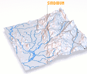 Places with similar names to Sindibum, Myanmar ::
// Santaboma (GH)
Disclaimer :: Information on this page comes without warranty of any kind |
||
|
Where is Sindibum? Elevation and coordinates ::
Latitude (lat): 24°0'0"N Longitude (lon): 97°19'0"E
Elevation (approx.): 578m (map arrows pan, magnifying glasses zoom) |
||
|
Visiting Sindibum? Hotel/Accommodation ::
Book a hotel in Sindibum Travel Guide ::
Buy a travel guide for Myanmar rental cars ::
car rental offers GPS waypoint ::
download a GPX waypoint (PoI) of Sindibum for your GPS receiver
|
||