|
search place name
|
||
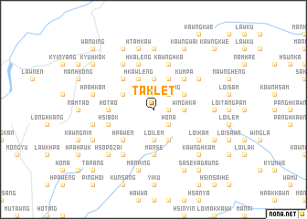
Taklet (Shan, Myanmar)Taklet is a town in the Shan region of Myanmar. An overview map of the region around Taklet is displayed below.
regional and 3d topo map of Taklet, Myanmar ::
Taklet airports ::
The nearest airport is LSH - Lashio, located 121.5 km south of Taklet.
Other airports nearby include MYT - Myitkyina (170.8 km north west), Nearby towns ::
Namkat (1.7km east) //
Loi-kang (2.5km north east) //
Ho-na (2.5km south east) //
Tung-aw (3.7km north) //
Winghka (3.4km east) //
Loi-lem (3.7km south) //
Hkawleng (4.1km north west) //
Mēntang (3.9km north west) //
Namhka (4.1km north east) //
Mān Kang (3.9km north east) //
Mān Pong (4.1km south east) //
Yi-ku (5.0km north west) //
Kumpa (5.0km north east) //
Hkai-lekhko (5.0km north east) //
Panglong (5.0km north east) //
Hpa-wen (5.0km south west) //
Ho-tao (5.1km west) //
Mān Sē (5.6km south) //
Mān Maü (5.6km south) //
Hkaleng (5.8km north) //
Hsi-bok (5.4km west) //
Kawnghka (5.8km north) //
Kapna (5.8km north) //
Hkawpang (6.3km north east) //
Hpao-chong (6.3km north east) //
Ho-kan (6.5km south west) //
Tinghsa (6.5km north west) //
Ka-hki (6.3km south east) //
Loi-kam (6.3km south east) //
[all distances 'as the bird flies' and approximate] 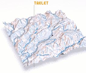 Places with similar names to Taklet, Myanmar ::
Disclaimer :: Information on this page comes without warranty of any kind |
||
|
Where is Taklet? Elevation and coordinates ::
Latitude (lat): 24°1'0"N Longitude (lon): 98°8'0"E
Elevation (approx.): 1321m (map arrows pan, magnifying glasses zoom) |
||
|
Visiting Taklet? Hotel/Accommodation ::
Book a hotel in Taklet Travel Guide ::
Buy a travel guide for Myanmar rental cars ::
car rental offers GPS waypoint ::
download a GPX waypoint (PoI) of Taklet for your GPS receiver
|
||