|
search place name
|
||
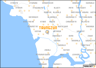
Taungzun (Myanmar)Taungzun is a town in Myanmar. An overview map of the region around Taungzun is displayed below.
regional and 3d topo map of Taungzun, Myanmar ::
Taungzun airports ::
The nearest airport is RGN - Yangon Intl, located 111.3 km west of Taungzun.
Nearby towns ::
Pauktaw (1.8km west) //
Sinin (3.7km north) //
Kyeinphan (3.7km north) //
Kinywa (3.5km west) //
Watanga (3.5km east) //
Kyibin (4.1km north west) //
Kokko (4.1km north east) //
Kawkadut (4.0km south east) //
Zothok (5.1km south east) //
Winpyan (5.1km north east) //
Kyauklongyi (5.6km west) //
Winka (5.6km west) //
Kyaungtaya (5.6km west) //
Kyaukyedwin (5.6km east) //
Alu-anauk (5.8km north) //
Ngamyin (7.4km north) //
Thabyeni (7.4km north) //
Zokali (7.4km south) //
Anaingpun (7.3km east) //
Zwegala (7.7km south east) //
Mayangon (7.7km north west) //
Ayetthema (8.0km north west) //
Thittokyun (8.0km south east) //
Alugale (8.2km north east) //
Paingdawe (10.3km north east) //
Muthin (10.3km south east) //
[all distances 'as the bird flies' and approximate] 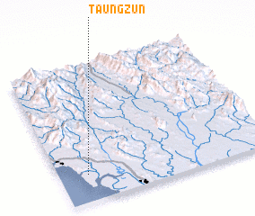 Places with similar names to Taungzun, Myanmar ::
Disclaimer :: Information on this page comes without warranty of any kind |
||
|
Where is Taungzun? Elevation and coordinates ::
Latitude (lat): 17°12'0"N Longitude (lon): 97°8'0"E
Elevation (approx.): 15m (map arrows pan, magnifying glasses zoom) |
||
|
Visiting Taungzun? Hotel/Accommodation ::
Book a hotel in Taungzun Travel Guide ::
Buy a travel guide for Myanmar rental cars ::
car rental offers GPS waypoint ::
download a GPX waypoint (PoI) of Taungzun for your GPS receiver
|
||