|
search place name
|
||
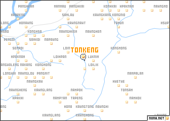
Tön-keng (Shan, Myanmar)Tön-keng is a town in the Shan region of Myanmar. An overview map of the region around Tön-keng is displayed below.
regional and 3d topo map of Tön-keng, Myanmar ::
Tön-keng airports ::
The nearest airport is LSH - Lashio, located 50.8 km north east of Tön-keng.
Other airports nearby include MDL - Mandalay Intl (186.8 km south west), HEH - Heho (215.6 km south), Nearby towns ::
Nawng-hsaü (1.9km north) //
Nam-mai-kut (1.9km south) //
Lüknim (1.7km east) //
Loi-lik (2.5km south east) //
Loi-nim (3.9km north west) //
Loi-hpan (5.1km west) //
Hpāk-to (5.1km west) //
Nawng-hen (5.8km north) //
Nawng-hkem (6.5km north west) //
Nā-keng (6.8km west) //
Kawng-nawt (7.6km north) //
Nampōk (7.6km south) //
Kōng-möng (7.1km east) //
Nā-pawng (7.8km north west) //
Nam-sam (7.8km south west) //
Man Kongmu (8.2km south west) //
Pānghkāng (9.0km north west) //
Hwe-twe (8.8km south east) //
Tā-mün (10.1km north east) //
[all distances 'as the bird flies' and approximate]  Places with similar names to Tön-keng, Myanmar ::
// Tingunak (RU)
// Duangniog (PH)
// Dunguang (PH)
// Tangaing (MM)
// Ta-ngun Ga (MM)
// Taunggaing (MM)
// Taunggaing (MM)
// Taunggaung (MM)
// Taunggaing (MM)
// Taunggaing (MM)
Disclaimer :: Information on this page comes without warranty of any kind |
||
|
Where is Tön-keng? Elevation and coordinates ::
Latitude (lat): 22°34'0"N Longitude (lon): 97°32'0"E
Elevation (approx.): 693m (map arrows pan, magnifying glasses zoom) |
||
|
Visiting Tön-keng? Hotel/Accommodation ::
Book a hotel in Tön-keng Travel Guide ::
Buy a travel guide for Myanmar rental cars ::
car rental offers GPS waypoint ::
download a GPX waypoint (PoI) of Tön-keng for your GPS receiver
|
||