|
search place name
|
||
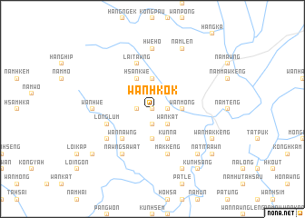
Wān Hkok (Shan, Myanmar)Wān Hkok is a town in the Shan region of Myanmar. An overview map of the region around Wān Hkok is displayed below.
regional and 3d topo map of Wān Hkok, Myanmar ::
Wān Hkok airports ::
The nearest airport is HEH - Heho, located 124.1 km west of Wān Hkok.
Other airports nearby include MOG - Mong Hsat (146.9 km east), KET - Kengtung (177.9 km east), THL - Tachilek Tachileik (215.0 km east), LSH - Lashio (218.1 km north), Nearby towns ::
Ho-loi-ai (0.0km north) //
Mawhsum (1.9km north) //
Wan Heng (1.9km south) //
Wān Möng (1.7km west) //
Hangloi (1.7km east) //
Ompok (2.5km north east) //
Wān Kat (2.5km south east) //
Wān Möng (3.5km east) //
Nawngwawn (3.7km north) //
Konglang (3.7km south) //
Hsankwè (4.1km north west) //
Hai-ning (4.1km south east) //
Kunna (4.1km south east) //
Nā-loi (4.1km south east) //
Wān Nawng (5.1km south west) //
Longlum (5.5km west) //
Makkeng (5.8km south) //
Lai-tawng (5.8km north) //
Nawngsa Wat (6.5km south west) //
Wān Möng (6.4km south west) //
Hwè-ho (7.4km north) //
Wān Hwe (6.9km west) //
Nā-ti (7.6km south east) //
Namlen (8.2km north east) //
Nawngmo (8.2km south east) //
Wān Makkeng (7.9km south east) //
Nawngkap (8.9km south west) //
Kunhsang (9.1km south east) //
Ta Awn (8.9km south east) //
[all distances 'as the bird flies' and approximate]  Places with similar names to Wān Hkok, Myanmar ::
Disclaimer :: Information on this page comes without warranty of any kind |
||
|
Where is Wān Hkok? Elevation and coordinates ::
Latitude (lat): 21°1'0"N Longitude (lon): 97°57'0"E
Elevation (approx.): 903m (map arrows pan, magnifying glasses zoom) |
||
|
Visiting Wān Hkok? Hotel/Accommodation ::
Book a hotel in Wān Hkok Travel Guide ::
Buy a travel guide for Myanmar rental cars ::
car rental offers GPS waypoint ::
download a GPX waypoint (PoI) of Wān Hkok for your GPS receiver
|
||