|
search place name
|
||
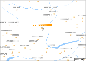
Wān Paw-hpal (Shan, Myanmar)Wān Paw-hpal is a town in the Shan region of Myanmar. An overview map of the region around Wān Paw-hpal is displayed below.
regional and 3d topo map of Wān Paw-hpal, Myanmar ::
Wān Paw-hpal airports ::
The nearest airport is THL - Tachilek Tachileik, located 77.3 km south west of Wān Paw-hpal.
Other airports nearby include KET - Kengtung (98.8 km north west), MOG - Mong Hsat (137.8 km west), LPQ - Luang Prabang Luang Phabang Intl (207.7 km south east), Nearby towns ::
Wān Ra-sa-wang (4.3km south west) //
Wān Na-yaw (6.1km north) //
Wān Namyāt (6.8km south west) //
Wān Hsa-li-mūn (8.0km south) //
Wān Sēng (8.3km south east) //
Wān Muh-hso (8.6km north east) //
Wān Hsenkohkam (10.0km south west) //
Wān Namhsi (10.4km south west) //
Wān Namwan (10.7km south west) //
[all distances 'as the bird flies' and approximate] 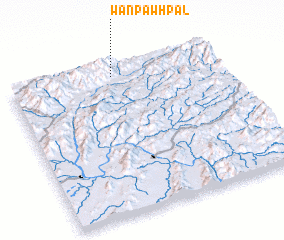 Places with similar names to Wān Paw-hpal, Myanmar :: Disclaimer :: Information on this page comes without warranty of any kind |
||
|
Where is Wān Paw-hpal? Elevation and coordinates ::
Latitude (lat): 20°56'5"N Longitude (lon): 100°30'9"E
Elevation (approx.): 851m (map arrows pan, magnifying glasses zoom) |
||
|
Visiting Wān Paw-hpal? Hotel/Accommodation ::
Book a hotel in Wān Paw-hpal Travel Guide ::
Buy a travel guide for Myanmar rental cars ::
car rental offers GPS waypoint ::
download a GPX waypoint (PoI) of Wān Paw-hpal for your GPS receiver
|
||