|
search place name
|
||
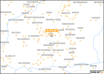
Aouraï (Aïn Defla, Algeria)Aouraï is a town in the Aïn Defla region of Algeria. An overview map of the region around Aouraï is displayed below.
regional and 3d topo map of Aouraï, Algeria ::
Aouraï airports ::
The nearest airport is QAS - Ech-cheliff Ech Cheliff, located 34.1 km south west of Aouraï.
Other airports nearby include TID - Tiaret Bou Chekif (113.0 km south), ALG - Algier Houari Boumediene (143.3 km east), MUW - Ghriss (187.1 km south west), Nearby towns ::
Hadjrai Izzaler (0.9km north) //
Aoud Izzane (0.9km north west) //
El Khemis (1.0km north east) //
Tamda (1.3km north west) //
Ouled Belhadj (1.6km west) //
Ouled Lehbib (1.8km north west) //
Labadnia (2.2km south east) //
El Ksar (2.3km north west) //
Lahdadoua (2.5km north east) //
Beni Merahba (2.4km east) //
Kerkouch (2.9km north west) //
Tacheta Zougagha (2.8km west) //
Ouled Ben Henda (3.5km south east) //
Mardas (3.3km north west) //
Bourzizene (4.0km south) //
Abla (3.3km west) //
Taghrourt (4.0km south) //
Ouled Salah (3.9km west) //
Tafoughart (4.1km north west) //
El Klaoucha (4.3km north west) //
Tabethacht (4.1km east) //
Ghoul Ou Melzi (4.5km north east) //
Imoumnayan (4.6km north west) //
Sidi Thabet (4.4km west) //
Ouled Tifidh (4.4km south west) //
Bou Khelfoune (5.4km north) //
Ghouali (5.6km south) //
Douar Ben Merhba (4.5km east) //
Medjadjra (5.9km south) //
[all distances 'as the bird flies' and approximate] 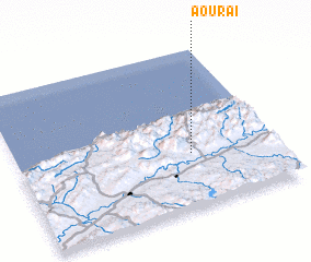 Places with similar names to Aouraï, Algeria ::
Disclaimer :: Information on this page comes without warranty of any kind |
||
|
Where is Aouraï? Elevation and coordinates ::
Latitude (lat): 36°20'43"N Longitude (lon): 1°40'28"E
Elevation (approx.): 434m (map arrows pan, magnifying glasses zoom) |
||
|
Visiting Aouraï? Hotel/Accommodation ::
Book a hotel in Aouraï Travel Guide ::
Buy a travel guide for Algeria rental cars ::
car rental offers GPS waypoint ::
download a GPX waypoint (PoI) of Aouraï for your GPS receiver
|
||