|
search place name
|
||
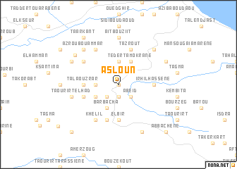
Asloun (Algeria)Asloun is a town in Algeria. An overview map of the region around Asloun is displayed below.
regional and 3d topo map of Asloun, Algeria ::
Asloun airports ::
The nearest airport is BJA - Bejaja Soummam, located 14.6 km north east of Asloun.
Other airports nearby include GJL - Jijel (82.5 km east), CZL - Constantine Mohamed Boudiaf Intl (151.1 km east), ALG - Algier Houari Boumediene (158.4 km west), BSK - Biskra (211.8 km south), Nearby towns ::
Tagma (0.0km north) //
Aït Ou Yaya (1.9km south) //
El Keïtoun (2.4km south west) //
Abeïd (2.4km south east) //
Taguemount (2.4km north east) //
Bou Mraou (3.7km north) //
Bouridene (3.0km west) //
Barbacha (4.0km south) //
Tedert Amokrane (4.0km north) //
Bou Aïch (3.5km south west) //
Irhil Hassene (4.5km east) //
Tala Ouzrar (4.5km west) //
Djelada (4.5km west) //
El Bir (5.6km south) //
Aït Aïssi (5.8km south) //
Tazrout (5.8km north) //
Taourirt (4.8km south west) //
Irhil Ollouanene (5.8km north west) //
Ihaïonnene (6.3km north west) //
Khelil (6.3km south west) //
Aït Bou Ziit (7.4km north) //
Taourirt el Had (6.2km west) //
Azrou Bou Ammar (7.1km north west) //
Manzekouane (7.1km north east) //
Irhil Ouznag (7.0km north west) //
El Meroudj (7.0km north east) //
Taourirt Maafa (8.0km south) //
Amizour (7.3km north west) //
Taarkant (8.7km north west) //
[all distances 'as the bird flies' and approximate]  Places with similar names to Asloun, Algeria ::
// Asseloun (MA)
// Aslun (PH)
// Asseln (DE)
// Asseln (DE)
// Aia Salina (IT)
// Aşlān (IQ)
// Ažuoliniai (LT)
// Ažuolynė (LT)
// Ažuolynė (LT)
// Aşlān (EG)
Disclaimer :: Information on this page comes without warranty of any kind |
||
|
Where is Asloun? Elevation and coordinates ::
Latitude (lat): 36°36'0"N Longitude (lon): 4°59'0"E
Elevation (approx.): 502m (map arrows pan, magnifying glasses zoom) |
||
|
Visiting Asloun? Hotel/Accommodation ::
Book a hotel in Asloun Travel Guide ::
Buy a travel guide for Algeria rental cars ::
car rental offers GPS waypoint ::
download a GPX waypoint (PoI) of Asloun for your GPS receiver
|
||