|
search place name
|
||
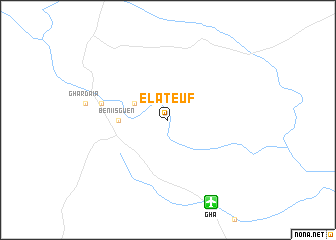
El Ateuf (Algeria)El Ateuf is a town in Algeria. An overview map of the region around El Ateuf is displayed below.
regional and 3d topo map of El Ateuf, Algeria ::
El Ateuf airports ::
The nearest airport is GHA - Ghardaia Noumerat, located 10.1 km south east of El Ateuf.
Other airports nearby include HRM - Tilrempt Hassi R Mel (65.8 km north west), LOO - Laghouat (163.1 km north west), OGX - Ouargla (168.2 km east), ELG - El Golea (226.5 km south), Nearby towns ::
Bou Noura (3.6km north west) //
Beni Isguen (4.7km west) //
Melika (6.5km west) //
[all distances 'as the bird flies' and approximate]  Places with similar names to El Ateuf, Algeria ::
Disclaimer :: Information on this page comes without warranty of any kind |
||
|
Where is El Ateuf? Elevation and coordinates ::
Latitude (lat): 32°28'0"N Longitude (lon): 3°45'0"E
Elevation (approx.): 457m (map arrows pan, magnifying glasses zoom) |
||
|
Visiting El Ateuf? Hotel/Accommodation ::
Book a hotel in El Ateuf Travel Guide ::
Buy a travel guide for Algeria rental cars ::
car rental offers GPS waypoint ::
download a GPX waypoint (PoI) of El Ateuf for your GPS receiver
|
||