|
search place name
|
||
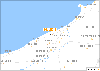
Fouka (Tipaza, Algeria)Fouka is a town in the Tipaza region of Algeria. An overview map of the region around Fouka is displayed below.
regional and 3d topo map of Fouka, Algeria ::
Fouka airports ::
The nearest airport is ALG - Algier Houari Boumediene, located 42.4 km east of Fouka.
Other airports nearby include QAS - Ech-cheliff Ech Cheliff (135.9 km west), TID - Tiaret Bou Chekif (186.4 km south west), Nearby towns ::
Fouka Marine (0.9km north east) //
Saïrher (2.8km south) //
Messaoud (3.2km south) //
Douaouda-Les Bains (3.3km north east) //
Kolea (3.7km south east) //
Saint-Maurice (3.6km east) //
Douaouda (4.4km east) //
Bou Ismaïl (4.6km south west) //
Berbessa (5.5km south) //
Chaïba (5.4km south west) //
Tekteka (6.8km south) //
ʼAïn Marmora (5.7km north east) //
Ben Nessah (7.2km south) //
Tefeschoun (6.9km south west) //
Nessassha (8.9km south) //
Chifalo (8.4km south west) //
Bou Haroun (8.4km south west) //
[all distances 'as the bird flies' and approximate] 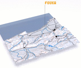 Places with similar names to Fouka, Algeria ::
Disclaimer :: Information on this page comes without warranty of any kind |
||
|
Where is Fouka? Elevation and coordinates ::
Latitude (lat): 36°39'40"N Longitude (lon): 2°44'32"E
Elevation (approx.): 113m (map arrows pan, magnifying glasses zoom) |
||
|
Visiting Fouka? Hotel/Accommodation ::
Book a hotel in Fouka Travel Guide ::
Buy a travel guide for Algeria rental cars ::
car rental offers GPS waypoint ::
download a GPX waypoint (PoI) of Fouka for your GPS receiver
|
||