|
search place name
|
||
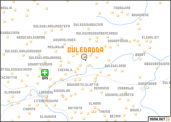
Ouled Adda (Chlef, Algeria)Ouled Adda is a town in the Chlef region of Algeria. An overview map of the region around Ouled Adda is displayed below.
regional and 3d topo map of Ouled Adda, Algeria ::
Ouled Adda airports ::
The nearest airport is QAS - Ech-cheliff Ech Cheliff, located 7.6 km west of Ouled Adda.
Other airports nearby include TID - Tiaret Bou Chekif (99.5 km south), MUW - Ghriss (161.6 km south west), ALG - Algier Houari Boumediene (169.4 km east), TAF - Oran Tafaraoui (191.6 km south west), Nearby towns ::
Boukaat el Hammam (1.1km south east) //
Ouled Rouadhi (1.4km south west) //
Douar Yermoul (1.5km north east) //
Douar Yarmoul (2.1km north east) //
Ouled Tifouria (2.1km south west) //
Labiod Medjadja (2.2km north west) //
Domaine Sayha Bouali (2.1km north east) //
Ouled Ahmed (2.5km north west) //
Boukaat Ouled Mʼghazi (3.0km south west) //
El Kedaouriya (3.3km south west) //
Domaine Yahi (3.0km west) //
Rezzama (3.7km south east) //
Domaine Hocine Babaï (3.6km south east) //
Cité Sablière (4.2km south) //
Boukaat Bsakra (4.2km south east) //
Ouled Ali Ben Djilali (4.2km north west) //
Oum ed Drou (4.5km south west) //
Boukaat el Hamaïssiya (4.7km south) //
Douar Ahl Chaoui (4.7km north east) //
Douar Touatria (4.9km north) //
Ouled Ben Youcef (4.1km east) //
Chekalil (4.5km south west) //
Ouled Ben Chebra (4.4km west) //
Mechta Bou Taïeb (4.8km north east) //
Domaine Chaib ed Doumi (4.5km west) //
Ouled Kaddour Ben Chaoui (5.6km north) //
Boukaat Ouled Bouali (5.2km south east) //
Douar el Mʼden (5.3km north west) //
Boukaat el Glaftia (6.1km south) //
[all distances 'as the bird flies' and approximate] 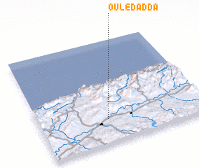 Places with similar names to Ouled Adda, Algeria ::
// Oulad Aïd (MA)
// Oulad Ayyad (MA)
// Oulad Daoud (MA)
// Oulad Daoud (MA)
// Ouled Aouda (MA)
// Ouled Daoud (MA)
// Old Duette (US)
// Olteţ (RO)
// Olteţu (RO)
// Olteţu (RO)
Disclaimer :: Information on this page comes without warranty of any kind |
||
|
Where is Ouled Adda? Elevation and coordinates ::
Latitude (lat): 36°14'12"N Longitude (lon): 1°24'40"E
Elevation (approx.): 153m (map arrows pan, magnifying glasses zoom) |
||
|
Visiting Ouled Adda? Hotel/Accommodation ::
Book a hotel in Ouled Adda Travel Guide ::
Buy a travel guide for Algeria rental cars ::
car rental offers GPS waypoint ::
download a GPX waypoint (PoI) of Ouled Adda for your GPS receiver
|
||